You are here: Home > Network List > IU - Global Seismograph Network (GSN - IRIS/USGS) Stations List
> Station COR Corvallis, Oregon, USA > Earthquake Result Viewer
COR Corvallis, Oregon, USA - Earthquake Result Viewer
| Earthquake location: |
Northern Bolivia |
| Earthquake latitude/longitude: |
-13.8/-67.6 |
| Earthquake time(UTC): |
1994/06/09 (160) 00:33:16 GMT |
| Earthquake Depth: |
637 km |
| Earthquake Magnitude: |
6.9 MB, 6.8 MS, 8.3 UNKNOWN, 8.2 MW |
| Earthquake Catalog/Contributor: |
WHDF/NEIC |
|
| Network: |
IU Global Seismograph Network (GSN - IRIS/USGS) |
| Station: |
COR Corvallis, Oregon, USA |
| Lat/Lon: |
44.59 N/123.30 W |
| Elevation: |
121 m |
|
| Distance: |
77.0 deg |
| Az: |
322.696 deg |
| Baz: |
124.527 deg |
| Ray Param: |
0.04852611 |
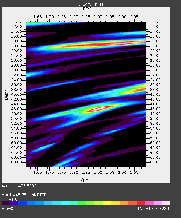
| Estimated Moho Depth: |
45.75 km |
| Estimated Crust Vp/Vs: |
1.90 |
| Assumed Crust Vp: |
6.566 km/s |
| Estimated Crust Vs: |
3.456 km/s |
| Estimated Crust Poisson's Ratio: |
0.31 |
|
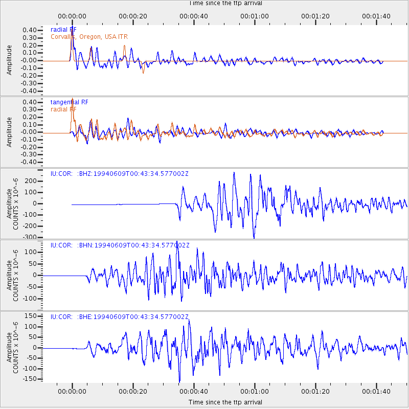
| Radial Match: |
96.5883 % |
| Radial Bump: |
400 |
| Transverse Match: |
92.73434 % |
| Transverse Bump: |
400 |
| SOD ConfigId: |
16938 |
| Insert Time: |
2010-03-04 20:05:42.234 +0000 |
| GWidth: |
2.5 |
| Max Bumps: |
400 |
| Tol: |
0.001 |
|
Signal To Noise
| Channel | StoN | STA | LTA |
| IU:COR: :BHN:19940609T00:43:34.577002Z | 5.4646373 | 1.2988902E-6 | 2.3769009E-7 |
| IU:COR: :BHE:19940609T00:43:34.577002Z | 7.3884916 | 2.4028805E-6 | 3.2521936E-7 |
| IU:COR: :BHZ:19940609T00:43:34.577002Z | 7.598451 | 6.6969546E-6 | 8.813579E-7 |
| Arrivals |
| Ps | 6.4 SECOND |
| PpPs | 20 SECOND |
| PsPs/PpSs | 26 SECOND |


