You are here: Home > Network List > IU - Global Seismograph Network (GSN - IRIS/USGS) Stations List
> Station COR Corvallis, Oregon, USA > Earthquake Result Viewer
COR Corvallis, Oregon, USA - Earthquake Result Viewer
| Earthquake location: |
Kuril Islands |
| Earthquake latitude/longitude: |
43.8/147.5 |
| Earthquake time(UTC): |
1994/10/04 (277) 13:51:08 GMT |
| Earthquake Depth: |
33 km |
| Earthquake Magnitude: |
5.6 MB |
| Earthquake Catalog/Contributor: |
WHDF/NEIC |
|
| Network: |
IU Global Seismograph Network (GSN - IRIS/USGS) |
| Station: |
COR Corvallis, Oregon, USA |
| Lat/Lon: |
44.59 N/123.30 W |
| Elevation: |
121 m |
|
| Distance: |
60.7 deg |
| Az: |
55.049 deg |
| Baz: |
303.886 deg |
| Ray Param: |
0.061330568 |
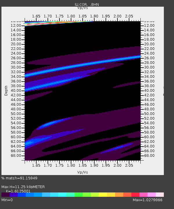
| Estimated Moho Depth: |
11.25 km |
| Estimated Crust Vp/Vs: |
1.61 |
| Assumed Crust Vp: |
6.566 km/s |
| Estimated Crust Vs: |
4.072 km/s |
| Estimated Crust Poisson's Ratio: |
0.19 |
|
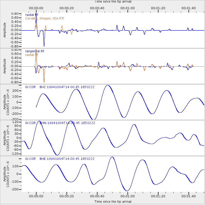
| Radial Match: |
91.15949 % |
| Radial Bump: |
400 |
| Transverse Match: |
87.03266 % |
| Transverse Bump: |
400 |
| SOD ConfigId: |
17000 |
| Insert Time: |
2010-03-04 20:05:59.927 +0000 |
| GWidth: |
2.5 |
| Max Bumps: |
400 |
| Tol: |
0.001 |
|
Signal To Noise
| Channel | StoN | STA | LTA |
| IU:COR: :BHN:19941004T14:00:45.185022Z | 2.6266987 | 1.10469635E-4 | 4.2056454E-5 |
| IU:COR: :BHE:19941004T14:00:45.185022Z | 0.9935497 | 9.72202E-5 | 9.785137E-5 |
| IU:COR: :BHZ:19941004T14:00:45.185022Z | 0.96888626 | 1.1491851E-4 | 1.1860888E-4 |
| Arrivals |
| Ps | 1.1 SECOND |
| PpPs | 4.2 SECOND |
| PsPs/PpSs | 5.4 SECOND |


