You are here: Home > Network List > CI - Caltech Regional Seismic Network Stations List
> Station GSC Goldstone, Goldstone Lake, CA, USA > Earthquake Result Viewer
GSC Goldstone, Goldstone Lake, CA, USA - Earthquake Result Viewer
| Earthquake location: |
Turkey |
| Earthquake latitude/longitude: |
40.7/29.9 |
| Earthquake time(UTC): |
1999/08/17 (229) 00:01:39 GMT |
| Earthquake Depth: |
17 km |
| Earthquake Magnitude: |
6.3 MB, 7.8 MS, 7.7 ME, 7.6 MW |
| Earthquake Catalog/Contributor: |
WHDF/NEIC |
|
| Network: |
CI Caltech Regional Seismic Network |
| Station: |
GSC Goldstone, Goldstone Lake, CA, USA |
| Lat/Lon: |
35.30 N/116.81 W |
| Elevation: |
1000 m |
|
| Distance: |
98.3 deg |
| Az: |
332.984 deg |
| Baz: |
24.956 deg |
| Ray Param: |
0.039925672 |
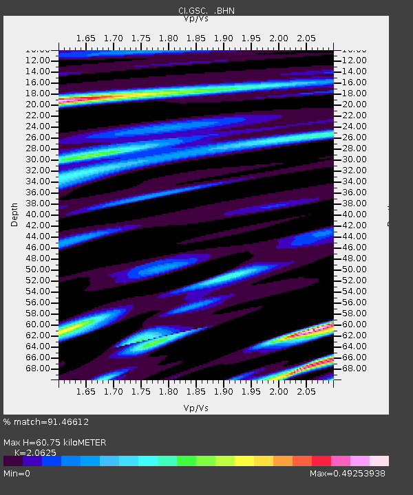
| Estimated Moho Depth: |
60.75 km |
| Estimated Crust Vp/Vs: |
2.06 |
| Assumed Crust Vp: |
6.276 km/s |
| Estimated Crust Vs: |
3.043 km/s |
| Estimated Crust Poisson's Ratio: |
0.35 |
|
| Radial Match: |
91.46612 % |
| Radial Bump: |
400 |
| Transverse Match: |
75.247536 % |
| Transverse Bump: |
400 |
| SOD ConfigId: |
3770 |
| Insert Time: |
2010-02-25 23:46:38.015 +0000 |
| GWidth: |
2.5 |
| Max Bumps: |
400 |
| Tol: |
0.001 |
|
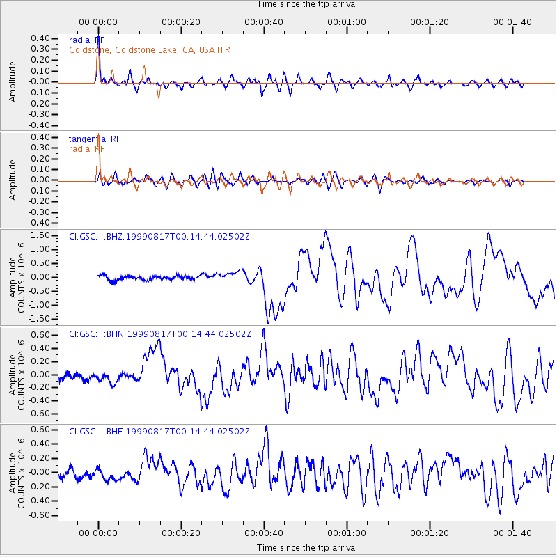
Signal To Noise
| Channel | StoN | STA | LTA |
| CI:GSC: :BHN:19990817T00:14:44.02502Z | 1.4762648 | 9.385724E-8 | 6.357751E-8 |
| CI:GSC: :BHE:19990817T00:14:44.02502Z | 1.2401386 | 7.7819024E-8 | 6.275026E-8 |
| CI:GSC: :BHZ:19990817T00:14:44.02502Z | 2.3982742 | 1.7980597E-7 | 7.497306E-8 |
| Arrivals |
| Ps | 10 SECOND |
| PpPs | 29 SECOND |
| PsPs/PpSs | 40 SECOND |


