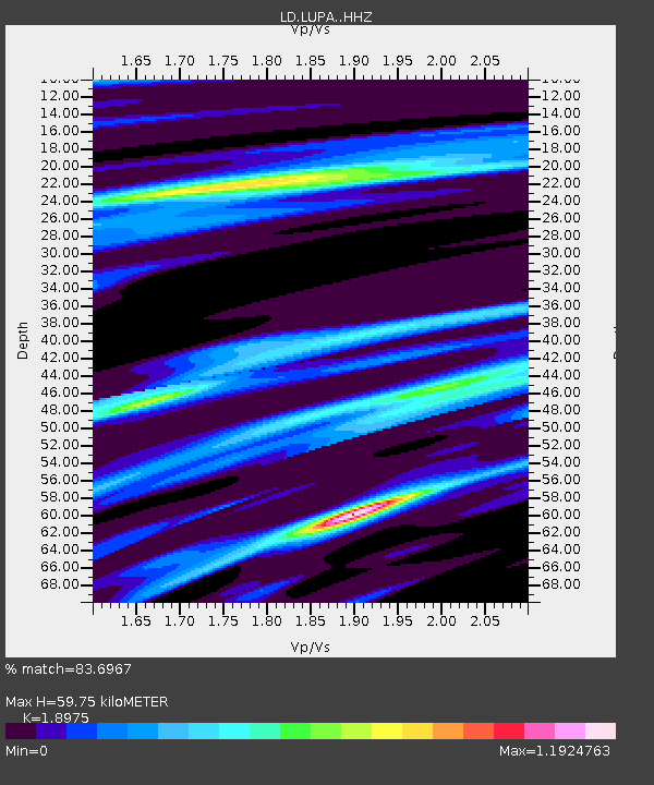
LUPA Lehigh University, PA - Earthquake Result Viewer

Earthquake location: Northern Mid-Atlantic Ridge
Earthquake latitude/longitude: 15.3/-46.0
Earthquake time(UTC): 2015/09/18 (261) 15:59:42 GMT
Earthquake Depth: 10 km
Earthquake Magnitude: 6.0 MWW, 5.9 MWB, 6.0 MWC
Earthquake Catalog/Contributor: NEIC PDE/NEIC COMCAT
Network: LD Lamont-Doherty Cooperative Seismographic Network
Station: LUPA Lehigh University, PA
Lat/Lon: 40.60 N/75.37 W
Elevation: 236 m
Distance: 35.9 deg
Az: 320.418 deg
Baz: 126.137 deg
Ray Param: 0.07697552
Estimated Moho Depth: 59.75 km
Estimated Crust Vp/Vs: 1.90
Assumed Crust Vp: 6.283 km/s
Estimated Crust Vs: 3.311 km/s
Estimated Crust Poisson's Ratio: 0.31
Radial Match: 83.6967 %
Radial Bump: 245
Transverse Match: 75.44542 %
Transverse Bump: 382
SOD ConfigId: 7422571
Insert Time: 2019-04-20 22:13:23.734 +0000
GWidth: 2.5
Max Bumps: 400
Tol: 0.001

Signal To Noise

ChannelStoNSTALTA
LD:LUPA: :HHZ:20150918T16:06:12.030015Z7.17154075.21198E-77.2675874E-8
LD:LUPA: :HHN:20150918T16:06:12.030015Z1.17047561.4804155E-71.2647983E-7
LD:LUPA: :HHE:20150918T16:06:12.030015Z3.55829452.5666557E-77.213162E-8
Arrivals
Ps9.1 SECOND
PpPs26 SECOND
PsPs/PpSs35 SECOND