You are here: Home > Network List > IU - Global Seismograph Network (GSN - IRIS/USGS) Stations List
> Station COR Corvallis, Oregon, USA > Earthquake Result Viewer
COR Corvallis, Oregon, USA - Earthquake Result Viewer
| Earthquake location: |
Near Coast Of Northern Chile |
| Earthquake latitude/longitude: |
-23.4/-70.3 |
| Earthquake time(UTC): |
1995/07/30 (211) 05:11:23 GMT |
| Earthquake Depth: |
47 km |
| Earthquake Magnitude: |
6.6 MB, 7.3 MS, 7.2 UNKNOWN, 8.1 MW |
| Earthquake Catalog/Contributor: |
WHDF/NEIC |
|
| Network: |
IU Global Seismograph Network (GSN - IRIS/USGS) |
| Station: |
COR Corvallis, Oregon, USA |
| Lat/Lon: |
44.59 N/123.30 W |
| Elevation: |
121 m |
|
| Distance: |
83.1 deg |
| Az: |
324.92 deg |
| Baz: |
132.343 deg |
| Ray Param: |
0.046319067 |
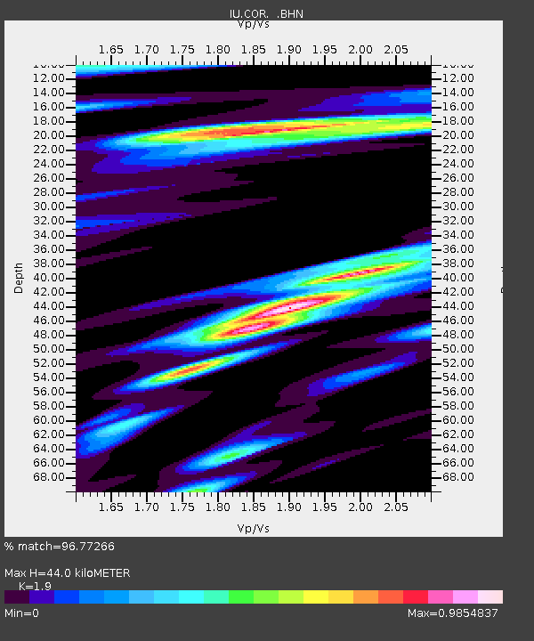
| Estimated Moho Depth: |
44.0 km |
| Estimated Crust Vp/Vs: |
1.90 |
| Assumed Crust Vp: |
6.566 km/s |
| Estimated Crust Vs: |
3.456 km/s |
| Estimated Crust Poisson's Ratio: |
0.31 |
|
| Radial Match: |
96.77266 % |
| Radial Bump: |
364 |
| Transverse Match: |
88.99947 % |
| Transverse Bump: |
400 |
| SOD ConfigId: |
6273 |
| Insert Time: |
2010-03-04 20:06:17.435 +0000 |
| GWidth: |
2.5 |
| Max Bumps: |
400 |
| Tol: |
0.001 |
|
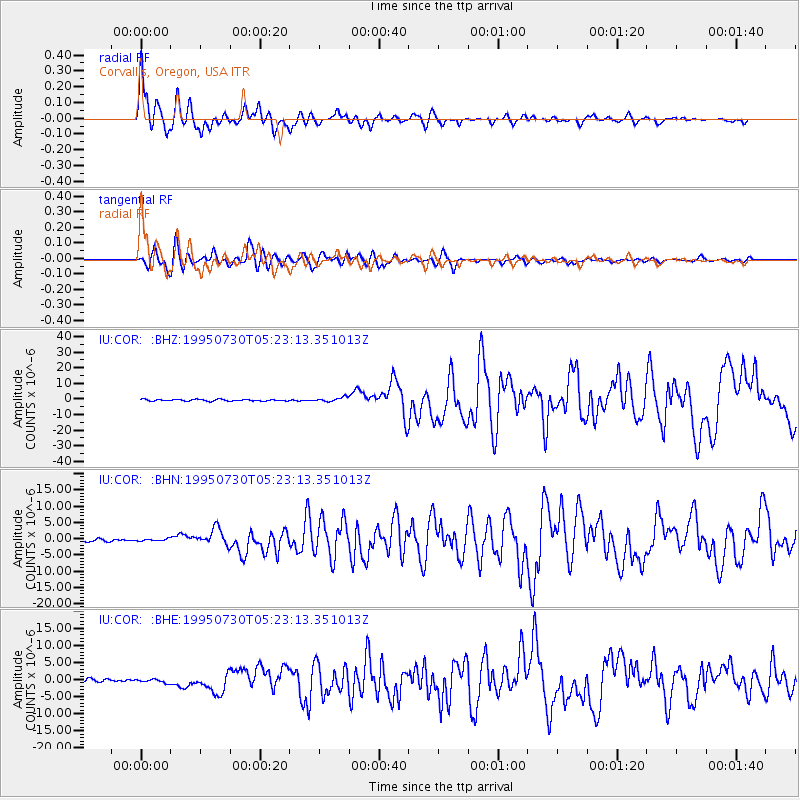
Signal To Noise
| Channel | StoN | STA | LTA |
| IU:COR: :BHN:19950730T05:23:13.351013Z | 0.7458742 | 3.0277965E-7 | 4.059393E-7 |
| IU:COR: :BHE:19950730T05:23:13.351013Z | 1.3140048 | 5.1114574E-7 | 3.8899836E-7 |
| IU:COR: :BHZ:19950730T05:23:13.351013Z | 2.5817406 | 1.347985E-6 | 5.2212255E-7 |
| Arrivals |
| Ps | 6.2 SECOND |
| PpPs | 19 SECOND |
| PsPs/PpSs | 25 SECOND |


