You are here: Home > Network List > LD - Lamont-Doherty Cooperative Seismographic Network Stations List
> Station UCCT University of Connecticut, Storrs, CT > Earthquake Result Viewer
UCCT University of Connecticut, Storrs, CT - Earthquake Result Viewer
| Earthquake location: |
Northern Mid-Atlantic Ridge |
| Earthquake latitude/longitude: |
15.3/-46.0 |
| Earthquake time(UTC): |
2015/09/18 (261) 15:59:42 GMT |
| Earthquake Depth: |
10 km |
| Earthquake Magnitude: |
6.0 MWW, 5.9 MWB, 6.0 MWC |
| Earthquake Catalog/Contributor: |
NEIC PDE/NEIC COMCAT |
|
| Network: |
LD Lamont-Doherty Cooperative Seismographic Network |
| Station: |
UCCT University of Connecticut, Storrs, CT |
| Lat/Lon: |
41.79 N/72.23 W |
| Elevation: |
200 m |
|
| Distance: |
34.8 deg |
| Az: |
324.601 deg |
| Baz: |
131.614 deg |
| Ray Param: |
0.07755581 |
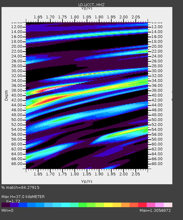
| Estimated Moho Depth: |
37.0 km |
| Estimated Crust Vp/Vs: |
1.72 |
| Assumed Crust Vp: |
6.472 km/s |
| Estimated Crust Vs: |
3.763 km/s |
| Estimated Crust Poisson's Ratio: |
0.24 |
|
| Radial Match: |
84.27915 % |
| Radial Bump: |
400 |
| Transverse Match: |
71.375626 % |
| Transverse Bump: |
400 |
| SOD ConfigId: |
7422571 |
| Insert Time: |
2019-04-20 22:13:33.366 +0000 |
| GWidth: |
2.5 |
| Max Bumps: |
400 |
| Tol: |
0.001 |
|

Signal To Noise
| Channel | StoN | STA | LTA |
| LD:UCCT: :HHZ:20150918T16:06:02.585007Z | 4.4763374 | 3.7544615E-7 | 8.3873516E-8 |
| LD:UCCT: :HHN:20150918T16:06:02.585007Z | 1.1282655 | 2.0841573E-7 | 1.8472224E-7 |
| LD:UCCT: :HHE:20150918T16:06:02.585007Z | 0.7567946 | 2.094093E-7 | 2.767056E-7 |
| Arrivals |
| Ps | 4.5 SECOND |
| PpPs | 14 SECOND |
| PsPs/PpSs | 19 SECOND |


