You are here: Home > Network List > IU - Global Seismograph Network (GSN - IRIS/USGS) Stations List
> Station COR Corvallis, Oregon, USA > Earthquake Result Viewer
COR Corvallis, Oregon, USA - Earthquake Result Viewer
| Earthquake location: |
Mariana Islands |
| Earthquake latitude/longitude: |
18.9/145.2 |
| Earthquake time(UTC): |
1995/08/23 (235) 07:06:02 GMT |
| Earthquake Depth: |
596 km |
| Earthquake Magnitude: |
6.3 MB, 6.3 UNKNOWN, 7.0 MW |
| Earthquake Catalog/Contributor: |
WHDF/NEIC |
|
| Network: |
IU Global Seismograph Network (GSN - IRIS/USGS) |
| Station: |
COR Corvallis, Oregon, USA |
| Lat/Lon: |
44.59 N/123.30 W |
| Elevation: |
121 m |
|
| Distance: |
78.1 deg |
| Az: |
46.895 deg |
| Baz: |
284.625 deg |
| Ray Param: |
0.04802611 |
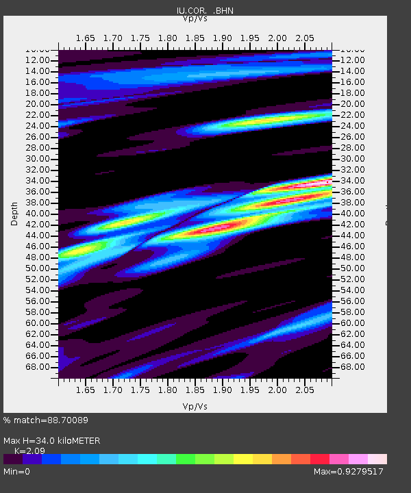
| Estimated Moho Depth: |
34.0 km |
| Estimated Crust Vp/Vs: |
2.09 |
| Assumed Crust Vp: |
6.566 km/s |
| Estimated Crust Vs: |
3.142 km/s |
| Estimated Crust Poisson's Ratio: |
0.35 |
|
| Radial Match: |
88.70089 % |
| Radial Bump: |
400 |
| Transverse Match: |
88.02734 % |
| Transverse Bump: |
400 |
| SOD ConfigId: |
6273 |
| Insert Time: |
2010-03-04 20:06:22.308 +0000 |
| GWidth: |
2.5 |
| Max Bumps: |
400 |
| Tol: |
0.001 |
|
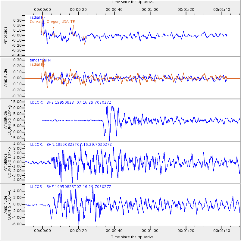
Signal To Noise
| Channel | StoN | STA | LTA |
| IU:COR: :BHN:19950823T07:16:29.703027Z | 0.7907975 | 1.8815547E-7 | 2.379313E-7 |
| IU:COR: :BHE:19950823T07:16:29.703027Z | 4.572844 | 9.136803E-7 | 1.998057E-7 |
| IU:COR: :BHZ:19950823T07:16:29.703027Z | 14.609089 | 3.832137E-6 | 2.6231183E-7 |
| Arrivals |
| Ps | 5.8 SECOND |
| PpPs | 16 SECOND |
| PsPs/PpSs | 21 SECOND |


