You are here: Home > Network List > IU - Global Seismograph Network (GSN - IRIS/USGS) Stations List
> Station COR Corvallis, Oregon, USA > Earthquake Result Viewer
COR Corvallis, Oregon, USA - Earthquake Result Viewer
| Earthquake location: |
Tonga Islands |
| Earthquake latitude/longitude: |
-15.2/-173.6 |
| Earthquake time(UTC): |
1995/04/07 (097) 22:06:58 GMT |
| Earthquake Depth: |
31 km |
| Earthquake Magnitude: |
6.7 MB, 8.0 MS, 7.5 UNKNOWN, 7.1 MD |
| Earthquake Catalog/Contributor: |
WHDF/NEIC |
|
| Network: |
IU Global Seismograph Network (GSN - IRIS/USGS) |
| Station: |
COR Corvallis, Oregon, USA |
| Lat/Lon: |
44.59 N/123.30 W |
| Elevation: |
121 m |
|
| Distance: |
75.0 deg |
| Az: |
34.685 deg |
| Baz: |
230.259 deg |
| Ray Param: |
0.051909056 |
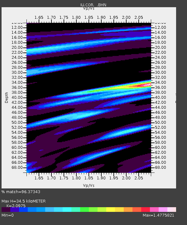
| Estimated Moho Depth: |
34.5 km |
| Estimated Crust Vp/Vs: |
2.10 |
| Assumed Crust Vp: |
6.566 km/s |
| Estimated Crust Vs: |
3.13 km/s |
| Estimated Crust Poisson's Ratio: |
0.35 |
|
| Radial Match: |
96.37343 % |
| Radial Bump: |
400 |
| Transverse Match: |
91.464165 % |
| Transverse Bump: |
400 |
| SOD ConfigId: |
6273 |
| Insert Time: |
2010-03-04 20:06:29.027 +0000 |
| GWidth: |
2.5 |
| Max Bumps: |
400 |
| Tol: |
0.001 |
|
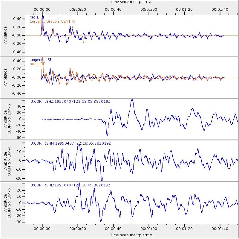
Signal To Noise
| Channel | StoN | STA | LTA |
| IU:COR: :BHN:19950407T22:18:05.382019Z | 1.6673392 | 1.3055133E-6 | 7.8299195E-7 |
| IU:COR: :BHE:19950407T22:18:05.382019Z | 2.1006646 | 1.4556034E-6 | 6.9292514E-7 |
| IU:COR: :BHZ:19950407T22:18:05.382019Z | 4.1469026 | 3.828213E-6 | 9.2314997E-7 |
| Arrivals |
| Ps | 5.9 SECOND |
| PpPs | 16 SECOND |
| PsPs/PpSs | 22 SECOND |


