You are here: Home > Network List > CI - Caltech Regional Seismic Network Stations List
> Station GSC Goldstone, Goldstone Lake, CA, USA > Earthquake Result Viewer
GSC Goldstone, Goldstone Lake, CA, USA - Earthquake Result Viewer
| Earthquake location: |
New Britain Region, P.N.G. |
| Earthquake latitude/longitude: |
-5.2/150.9 |
| Earthquake time(UTC): |
1999/05/10 (130) 20:33:02 GMT |
| Earthquake Depth: |
138 km |
| Earthquake Magnitude: |
6.5 MB, 6.8 MS, 7.1 MW, 6.5 MB |
| Earthquake Catalog/Contributor: |
WHDF/NEIC |
|
| Network: |
CI Caltech Regional Seismic Network |
| Station: |
GSC Goldstone, Goldstone Lake, CA, USA |
| Lat/Lon: |
35.30 N/116.81 W |
| Elevation: |
1000 m |
|
| Distance: |
94.8 deg |
| Az: |
55.104 deg |
| Baz: |
267.128 deg |
| Ray Param: |
0.040838547 |
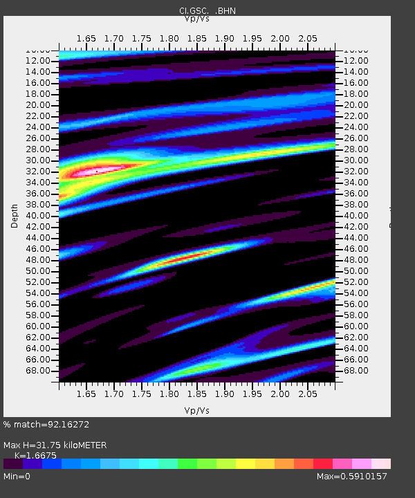
| Estimated Moho Depth: |
31.75 km |
| Estimated Crust Vp/Vs: |
1.67 |
| Assumed Crust Vp: |
6.276 km/s |
| Estimated Crust Vs: |
3.764 km/s |
| Estimated Crust Poisson's Ratio: |
0.22 |
|
| Radial Match: |
92.16272 % |
| Radial Bump: |
400 |
| Transverse Match: |
82.59679 % |
| Transverse Bump: |
400 |
| SOD ConfigId: |
3770 |
| Insert Time: |
2010-02-25 23:46:43.934 +0000 |
| GWidth: |
2.5 |
| Max Bumps: |
400 |
| Tol: |
0.001 |
|
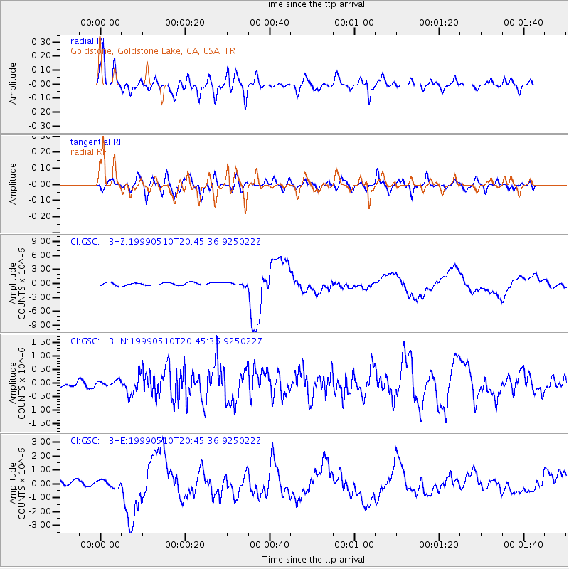
Signal To Noise
| Channel | StoN | STA | LTA |
| CI:GSC: :BHN:19990510T20:45:36.925022Z | 0.6587561 | 8.578322E-8 | 1.3022E-7 |
| CI:GSC: :BHE:19990510T20:45:36.925022Z | 1.6665795 | 2.5689667E-7 | 1.5414606E-7 |
| CI:GSC: :BHZ:19990510T20:45:36.925022Z | 1.0389266 | 3.0587594E-7 | 2.9441534E-7 |
| Arrivals |
| Ps | 3.4 SECOND |
| PpPs | 13 SECOND |
| PsPs/PpSs | 17 SECOND |


