You are here: Home > Network List > N4 - Central and EAstern US Network Stations List
> Station O44A Mansfield, IL, USA > Earthquake Result Viewer
O44A Mansfield, IL, USA - Earthquake Result Viewer
| Earthquake location: |
Northern Mid-Atlantic Ridge |
| Earthquake latitude/longitude: |
15.3/-46.0 |
| Earthquake time(UTC): |
2015/09/18 (261) 15:59:42 GMT |
| Earthquake Depth: |
10 km |
| Earthquake Magnitude: |
6.0 MWW, 5.9 MWB, 6.0 MWC |
| Earthquake Catalog/Contributor: |
NEIC PDE/NEIC COMCAT |
|
| Network: |
N4 Central and EAstern US Network |
| Station: |
O44A Mansfield, IL, USA |
| Lat/Lon: |
40.15 N/88.47 W |
| Elevation: |
213 m |
|
| Distance: |
44.5 deg |
| Az: |
312.354 deg |
| Baz: |
111.482 deg |
| Ray Param: |
0.07190314 |
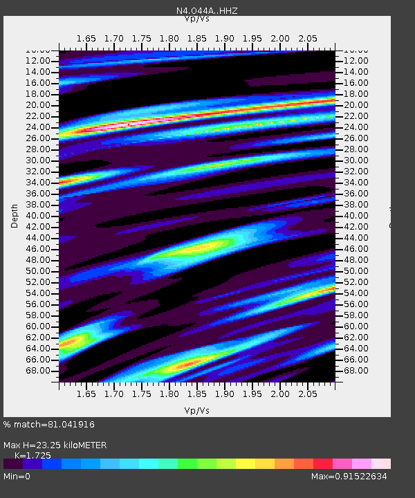
| Estimated Moho Depth: |
23.25 km |
| Estimated Crust Vp/Vs: |
1.73 |
| Assumed Crust Vp: |
6.498 km/s |
| Estimated Crust Vs: |
3.767 km/s |
| Estimated Crust Poisson's Ratio: |
0.25 |
|
| Radial Match: |
81.041916 % |
| Radial Bump: |
400 |
| Transverse Match: |
68.01911 % |
| Transverse Bump: |
400 |
| SOD ConfigId: |
7422571 |
| Insert Time: |
2019-04-20 22:14:31.037 +0000 |
| GWidth: |
2.5 |
| Max Bumps: |
400 |
| Tol: |
0.001 |
|

Signal To Noise
| Channel | StoN | STA | LTA |
| N4:O44A: :HHZ:20150918T16:07:22.90001Z | 4.1995077 | 4.535259E-7 | 1.0799501E-7 |
| N4:O44A: :HHN:20150918T16:07:22.90001Z | 1.586256 | 2.0929228E-7 | 1.3194104E-7 |
| N4:O44A: :HHE:20150918T16:07:22.90001Z | 2.1152263 | 2.7108396E-7 | 1.2815838E-7 |
| Arrivals |
| Ps | 2.8 SECOND |
| PpPs | 9.1 SECOND |
| PsPs/PpSs | 12 SECOND |


