You are here: Home > Network List > IU - Global Seismograph Network (GSN - IRIS/USGS) Stations List
> Station COR Corvallis, Oregon, USA > Earthquake Result Viewer
COR Corvallis, Oregon, USA - Earthquake Result Viewer
| Earthquake location: |
Tonga Islands |
| Earthquake latitude/longitude: |
-15.3/-173.1 |
| Earthquake time(UTC): |
1996/08/05 (218) 02:08:58 GMT |
| Earthquake Depth: |
41 km |
| Earthquake Magnitude: |
6.0 MB, 6.7 MS, 6.7 UNKNOWN, 6.2 ME |
| Earthquake Catalog/Contributor: |
WHDF/NEIC |
|
| Network: |
IU Global Seismograph Network (GSN - IRIS/USGS) |
| Station: |
COR Corvallis, Oregon, USA |
| Lat/Lon: |
44.59 N/123.30 W |
| Elevation: |
121 m |
|
| Distance: |
74.8 deg |
| Az: |
34.451 deg |
| Baz: |
229.827 deg |
| Ray Param: |
0.052008405 |
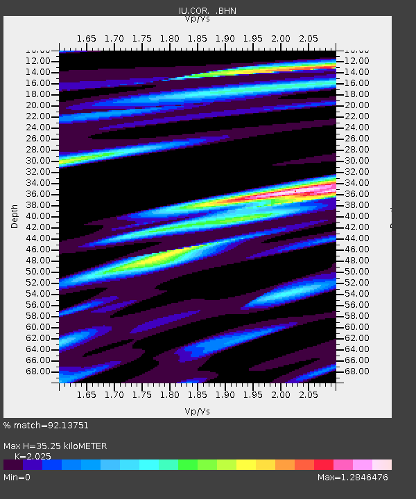
| Estimated Moho Depth: |
35.25 km |
| Estimated Crust Vp/Vs: |
2.03 |
| Assumed Crust Vp: |
6.566 km/s |
| Estimated Crust Vs: |
3.243 km/s |
| Estimated Crust Poisson's Ratio: |
0.34 |
|
| Radial Match: |
92.13751 % |
| Radial Bump: |
400 |
| Transverse Match: |
86.54827 % |
| Transverse Bump: |
400 |
| SOD ConfigId: |
6273 |
| Insert Time: |
2010-03-04 20:06:41.133 +0000 |
| GWidth: |
2.5 |
| Max Bumps: |
400 |
| Tol: |
0.001 |
|
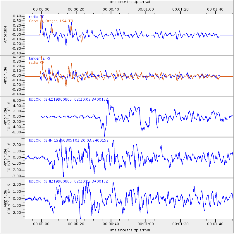
Signal To Noise
| Channel | StoN | STA | LTA |
| IU:COR: :BHN:19960805T02:20:03.340015Z | 2.232964 | 3.4153132E-7 | 1.5294975E-7 |
| IU:COR: :BHE:19960805T02:20:03.340015Z | 1.8098134 | 2.3436846E-7 | 1.2949869E-7 |
| IU:COR: :BHZ:19960805T02:20:03.340015Z | 5.2918367 | 1.3572868E-6 | 2.5648689E-7 |
| Arrivals |
| Ps | 5.7 SECOND |
| PpPs | 16 SECOND |
| PsPs/PpSs | 21 SECOND |


