You are here: Home > Network List > NE - New England Seismic Network Stations List
> Station PQI Presque Isle, ME, USA > Earthquake Result Viewer
PQI Presque Isle, ME, USA - Earthquake Result Viewer

| Earthquake location: |
Near East Coast Of Honshu, Japan |
| Earthquake latitude/longitude: |
38.9/142.0 |
| Earthquake time(UTC): |
2015/05/12 (132) 21:12:58 GMT |
| Earthquake Depth: |
39 km |
| Earthquake Magnitude: |
6.8 MWP, 6.8 MI |
| Earthquake Catalog/Contributor: |
NEIC PDE/NEIC COMCAT |
|
| Network: |
NE New England Seismic Network |
| Station: |
PQI Presque Isle, ME, USA |
| Lat/Lon: |
46.67 N/68.02 W |
| Elevation: |
162 m |
|
| Distance: |
90.7 deg |
| Az: |
20.174 deg |
| Baz: |
336.998 deg |
| Ray Param: |
0.041652102 |
| Estimated Moho Depth: |
49.75 km |
| Estimated Crust Vp/Vs: |
1.90 |
| Assumed Crust Vp: |
6.419 km/s |
| Estimated Crust Vs: |
3.374 km/s |
| Estimated Crust Poisson's Ratio: |
0.31 |
|
| Radial Match: |
82.330956 % |
| Radial Bump: |
383 |
| Transverse Match: |
40.921494 % |
| Transverse Bump: |
341 |
| SOD ConfigId: |
976571 |
| Insert Time: |
2015-05-26 21:35:45.361 +0000 |
| GWidth: |
2.5 |
| Max Bumps: |
400 |
| Tol: |
0.001 |
|
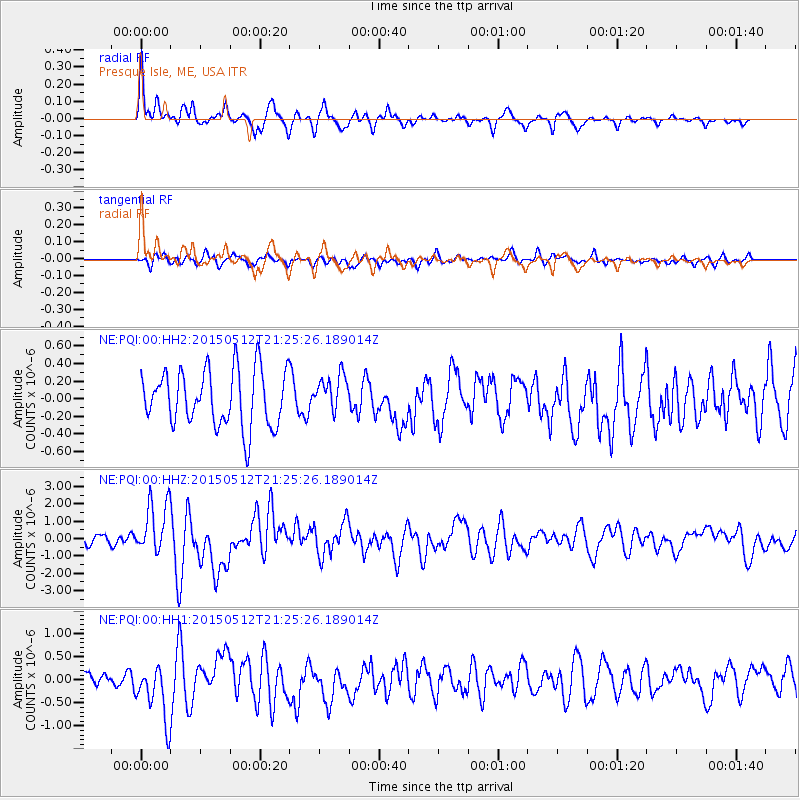
Signal To Noise
| Channel | StoN | STA | LTA |
| NE:PQI:00:HHZ:20150512T21:25:26.189014Z | 6.5638247 | 1.5070743E-6 | 2.2960309E-7 |
| NE:PQI:00:HH1:20150512T21:25:26.189014Z | 3.5405688 | 6.289952E-7 | 1.7765372E-7 |
| NE:PQI:00:HH2:20150512T21:25:26.189014Z | 0.65387356 | 2.0809065E-7 | 3.1824297E-7 |
| Arrivals |
| Ps | 7.1 SECOND |
| PpPs | 22 SECOND |
| PsPs/PpSs | 29 SECOND |


