You are here: Home > Network List > N4 - Central and EAstern US Network Stations List
> Station T47A Sharon Grove, KY, USA > Earthquake Result Viewer
T47A Sharon Grove, KY, USA - Earthquake Result Viewer
| Earthquake location: |
Northern Mid-Atlantic Ridge |
| Earthquake latitude/longitude: |
15.3/-46.0 |
| Earthquake time(UTC): |
2015/09/18 (261) 15:59:42 GMT |
| Earthquake Depth: |
10 km |
| Earthquake Magnitude: |
6.0 MWW, 5.9 MWB, 6.0 MWC |
| Earthquake Catalog/Contributor: |
NEIC PDE/NEIC COMCAT |
|
| Network: |
N4 Central and EAstern US Network |
| Station: |
T47A Sharon Grove, KY, USA |
| Lat/Lon: |
36.99 N/87.11 W |
| Elevation: |
217 m |
|
| Distance: |
42.4 deg |
| Az: |
308.593 deg |
| Baz: |
109.595 deg |
| Ray Param: |
0.07322486 |
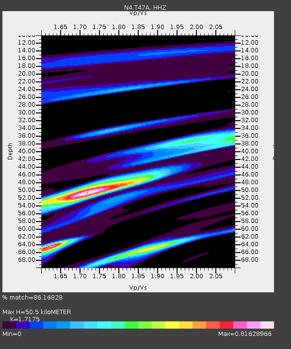
| Estimated Moho Depth: |
50.5 km |
| Estimated Crust Vp/Vs: |
1.72 |
| Assumed Crust Vp: |
6.444 km/s |
| Estimated Crust Vs: |
3.752 km/s |
| Estimated Crust Poisson's Ratio: |
0.24 |
|
| Radial Match: |
86.16828 % |
| Radial Bump: |
307 |
| Transverse Match: |
57.78587 % |
| Transverse Bump: |
400 |
| SOD ConfigId: |
7422571 |
| Insert Time: |
2019-04-20 22:14:50.561 +0000 |
| GWidth: |
2.5 |
| Max Bumps: |
400 |
| Tol: |
0.001 |
|

Signal To Noise
| Channel | StoN | STA | LTA |
| N4:T47A: :HHZ:20150918T16:07:05.909989Z | 4.537103 | 3.6983346E-7 | 8.151312E-8 |
| N4:T47A: :HHN:20150918T16:07:05.909989Z | 1.6570435 | 1.2312913E-7 | 7.430651E-8 |
| N4:T47A: :HHE:20150918T16:07:05.909989Z | 2.2762697 | 2.136743E-7 | 9.3870376E-8 |
| Arrivals |
| Ps | 6.0 SECOND |
| PpPs | 20 SECOND |
| PsPs/PpSs | 26 SECOND |


