You are here: Home > Network List > IU - Global Seismograph Network (GSN - IRIS/USGS) Stations List
> Station COR Corvallis, Oregon, USA > Earthquake Result Viewer
COR Corvallis, Oregon, USA - Earthquake Result Viewer
| Earthquake location: |
Near Coast Of Central Chile |
| Earthquake latitude/longitude: |
-30.9/-71.2 |
| Earthquake time(UTC): |
1997/10/15 (288) 01:03:33 GMT |
| Earthquake Depth: |
58 km |
| Earthquake Magnitude: |
6.8 MB, 6.8 MS, 7.3 UNKNOWN, 7.1 MW |
| Earthquake Catalog/Contributor: |
WHDF/NEIC |
|
| Network: |
IU Global Seismograph Network (GSN - IRIS/USGS) |
| Station: |
COR Corvallis, Oregon, USA |
| Lat/Lon: |
44.59 N/123.30 W |
| Elevation: |
121 m |
|
| Distance: |
88.9 deg |
| Az: |
325.679 deg |
| Baz: |
137.311 deg |
| Ray Param: |
0.042154208 |
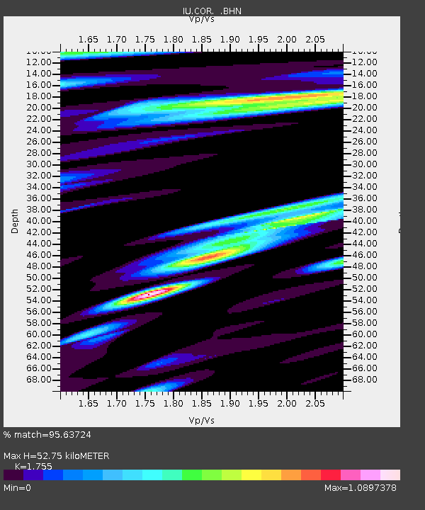
| Estimated Moho Depth: |
52.75 km |
| Estimated Crust Vp/Vs: |
1.75 |
| Assumed Crust Vp: |
6.566 km/s |
| Estimated Crust Vs: |
3.741 km/s |
| Estimated Crust Poisson's Ratio: |
0.26 |
|
| Radial Match: |
95.63724 % |
| Radial Bump: |
400 |
| Transverse Match: |
89.749794 % |
| Transverse Bump: |
400 |
| SOD ConfigId: |
6273 |
| Insert Time: |
2010-03-04 20:07:11.321 +0000 |
| GWidth: |
2.5 |
| Max Bumps: |
400 |
| Tol: |
0.001 |
|
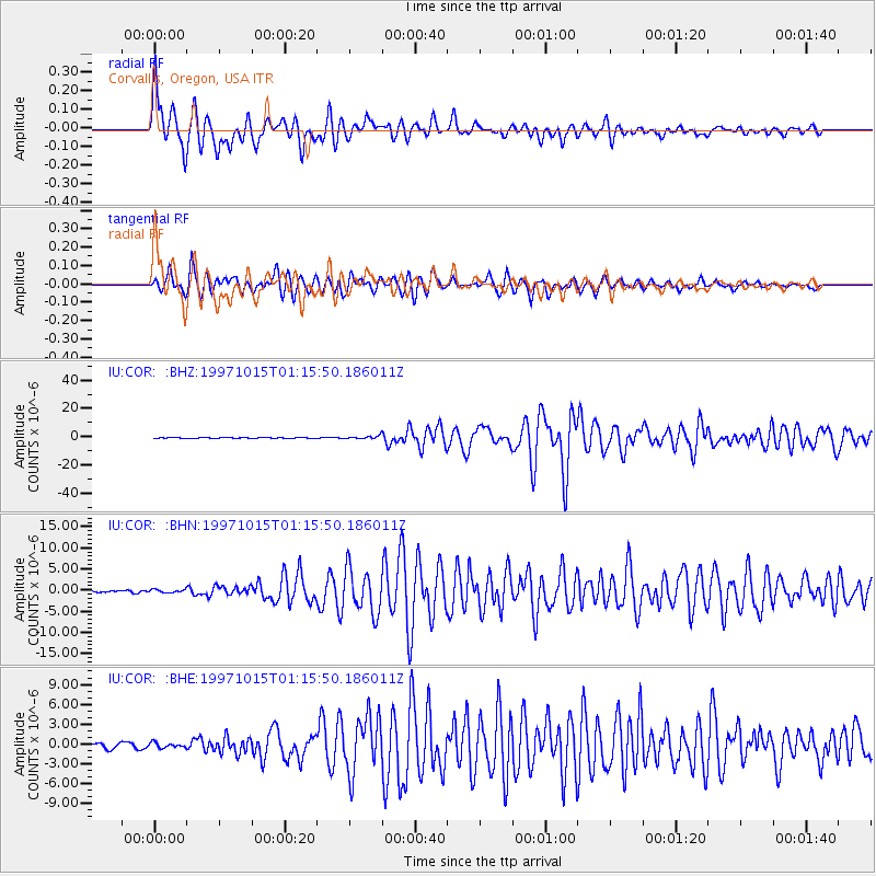
Signal To Noise
| Channel | StoN | STA | LTA |
| IU:COR: :BHN:19971015T01:15:50.186011Z | 1.3354838 | 3.7629624E-7 | 2.817677E-7 |
| IU:COR: :BHE:19971015T01:15:50.186011Z | 1.0437729 | 3.8303114E-7 | 3.6696787E-7 |
| IU:COR: :BHZ:19971015T01:15:50.186011Z | 3.4385977 | 1.0336331E-6 | 3.005973E-7 |
| Arrivals |
| Ps | 6.2 SECOND |
| PpPs | 22 SECOND |
| PsPs/PpSs | 28 SECOND |


