You are here: Home > Network List > IU - Global Seismograph Network (GSN - IRIS/USGS) Stations List
> Station COR Corvallis, Oregon, USA > Earthquake Result Viewer
COR Corvallis, Oregon, USA - Earthquake Result Viewer
| Earthquake location: |
Near Coast Of Central Chile |
| Earthquake latitude/longitude: |
-32.3/-71.3 |
| Earthquake time(UTC): |
1998/07/29 (210) 07:14:24 GMT |
| Earthquake Depth: |
51 km |
| Earthquake Magnitude: |
6.3 MB, 6.5 UNKNOWN, 6.5 ME |
| Earthquake Catalog/Contributor: |
WHDF/NEIC |
|
| Network: |
IU Global Seismograph Network (GSN - IRIS/USGS) |
| Station: |
COR Corvallis, Oregon, USA |
| Lat/Lon: |
44.59 N/123.30 W |
| Elevation: |
121 m |
|
| Distance: |
90.0 deg |
| Az: |
325.722 deg |
| Baz: |
138.132 deg |
| Ray Param: |
0.041697454 |
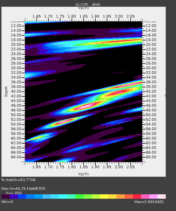
| Estimated Moho Depth: |
46.25 km |
| Estimated Crust Vp/Vs: |
1.86 |
| Assumed Crust Vp: |
6.566 km/s |
| Estimated Crust Vs: |
3.54 km/s |
| Estimated Crust Poisson's Ratio: |
0.30 |
|
| Radial Match: |
93.7706 % |
| Radial Bump: |
400 |
| Transverse Match: |
89.35981 % |
| Transverse Bump: |
400 |
| SOD ConfigId: |
9875 |
| Insert Time: |
2010-03-04 20:07:20.989 +0000 |
| GWidth: |
2.5 |
| Max Bumps: |
400 |
| Tol: |
0.001 |
|
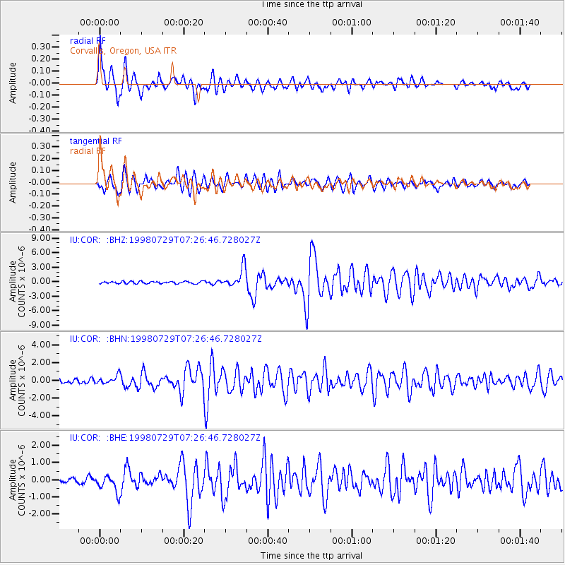
Signal To Noise
| Channel | StoN | STA | LTA |
| IU:COR: :BHN:19980729T07:26:46.728027Z | 1.9402384 | 4.854844E-7 | 2.5021896E-7 |
| IU:COR: :BHE:19980729T07:26:46.728027Z | 3.1688972 | 5.144013E-7 | 1.6232818E-7 |
| IU:COR: :BHZ:19980729T07:26:46.728027Z | 9.857313 | 2.100205E-6 | 2.130606E-7 |
| Arrivals |
| Ps | 6.1 SECOND |
| PpPs | 20 SECOND |
| PsPs/PpSs | 26 SECOND |


