You are here: Home > Network List > IU - Global Seismograph Network (GSN - IRIS/USGS) Stations List
> Station COR Corvallis, Oregon, USA > Earthquake Result Viewer
COR Corvallis, Oregon, USA - Earthquake Result Viewer
| Earthquake location: |
Michoacan, Mexico |
| Earthquake latitude/longitude: |
18.2/-102.8 |
| Earthquake time(UTC): |
1997/01/11 (011) 20:28:26 GMT |
| Earthquake Depth: |
33 km |
| Earthquake Magnitude: |
6.5 MB, 6.9 MS, 7.1 UNKNOWN, 7.0 ME |
| Earthquake Catalog/Contributor: |
WHDF/NEIC |
|
| Network: |
IU Global Seismograph Network (GSN - IRIS/USGS) |
| Station: |
COR Corvallis, Oregon, USA |
| Lat/Lon: |
44.59 N/123.30 W |
| Elevation: |
121 m |
|
| Distance: |
31.4 deg |
| Az: |
331.244 deg |
| Baz: |
140.213 deg |
| Ray Param: |
0.079034805 |
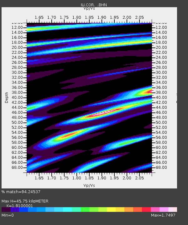
| Estimated Moho Depth: |
45.75 km |
| Estimated Crust Vp/Vs: |
1.91 |
| Assumed Crust Vp: |
6.566 km/s |
| Estimated Crust Vs: |
3.438 km/s |
| Estimated Crust Poisson's Ratio: |
0.31 |
|
| Radial Match: |
94.24537 % |
| Radial Bump: |
400 |
| Transverse Match: |
84.17511 % |
| Transverse Bump: |
400 |
| SOD ConfigId: |
4480 |
| Insert Time: |
2010-03-04 20:07:34.904 +0000 |
| GWidth: |
2.5 |
| Max Bumps: |
400 |
| Tol: |
0.001 |
|
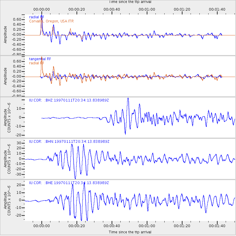
Signal To Noise
| Channel | StoN | STA | LTA |
| IU:COR: :BHN:19970111T20:34:13.838989Z | 4.0075245 | 2.012826E-6 | 5.022617E-7 |
| IU:COR: :BHE:19970111T20:34:13.838989Z | 2.2326286 | 7.4272543E-7 | 3.326686E-7 |
| IU:COR: :BHZ:19970111T20:34:13.838989Z | 2.1650996 | 8.028864E-7 | 3.7083115E-7 |
| Arrivals |
| Ps | 6.9 SECOND |
| PpPs | 19 SECOND |
| PsPs/PpSs | 26 SECOND |


