You are here: Home > Network List > 7A - Mid-Atlantic Geophysical Integrative Collaboration Stations List
> Station MOLE Hinton, Virginia USA > Earthquake Result Viewer
MOLE Hinton, Virginia USA - Earthquake Result Viewer
| Earthquake location: |
Off Coast Of Central Chile |
| Earthquake latitude/longitude: |
-29.7/-72.1 |
| Earthquake time(UTC): |
2015/09/19 (262) 05:06:47 GMT |
| Earthquake Depth: |
10 km |
| Earthquake Magnitude: |
5.8 MWR |
| Earthquake Catalog/Contributor: |
NEIC PDE/NEIC COMCAT |
|
| Network: |
7A Mid-Atlantic Geophysical Integrative Collaboration |
| Station: |
MOLE Hinton, Virginia USA |
| Lat/Lon: |
38.49 N/79.02 W |
| Elevation: |
487 m |
|
| Distance: |
68.1 deg |
| Az: |
354.172 deg |
| Baz: |
173.533 deg |
| Ray Param: |
0.05652413 |
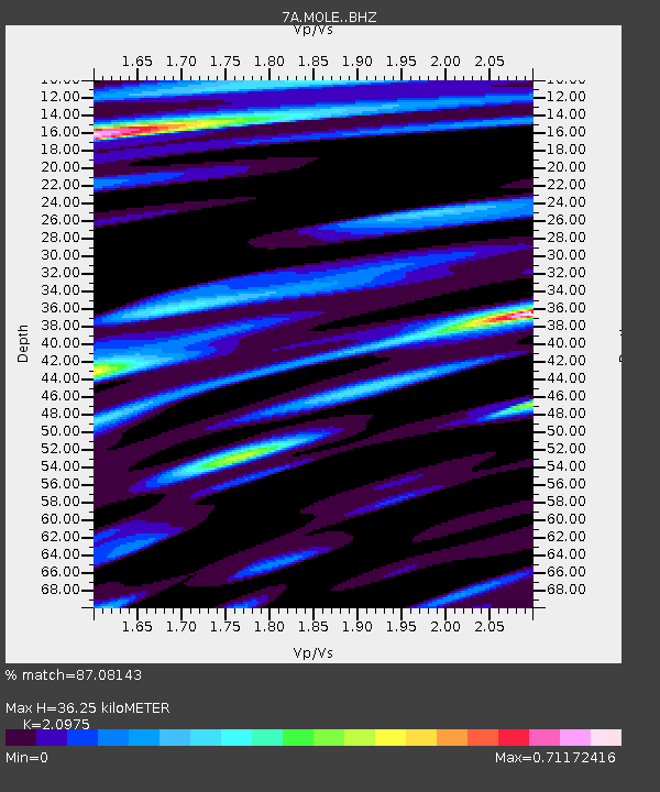
| Estimated Moho Depth: |
36.25 km |
| Estimated Crust Vp/Vs: |
2.10 |
| Assumed Crust Vp: |
6.159 km/s |
| Estimated Crust Vs: |
2.936 km/s |
| Estimated Crust Poisson's Ratio: |
0.35 |
|
| Radial Match: |
87.08143 % |
| Radial Bump: |
352 |
| Transverse Match: |
80.11443 % |
| Transverse Bump: |
360 |
| SOD ConfigId: |
7422571 |
| Insert Time: |
2019-04-20 22:20:50.576 +0000 |
| GWidth: |
2.5 |
| Max Bumps: |
400 |
| Tol: |
0.001 |
|

Signal To Noise
| Channel | StoN | STA | LTA |
| 7A:MOLE: :BHZ:20150919T05:17:16.759973Z | 2.4088047 | 4.500948E-7 | 1.8685401E-7 |
| 7A:MOLE: :BHN:20150919T05:17:16.759973Z | 2.8923595 | 2.5700683E-7 | 8.885715E-8 |
| 7A:MOLE: :BHE:20150919T05:17:16.759973Z | 0.80748534 | 7.939813E-8 | 9.832763E-8 |
| Arrivals |
| Ps | 6.7 SECOND |
| PpPs | 18 SECOND |
| PsPs/PpSs | 24 SECOND |


