You are here: Home > Network List > CI - Caltech Regional Seismic Network Stations List
> Station GSC Goldstone, Goldstone Lake, CA, USA > Earthquake Result Viewer
GSC Goldstone, Goldstone Lake, CA, USA - Earthquake Result Viewer
| Earthquake location: |
Southern Bolivia |
| Earthquake latitude/longitude: |
-20.9/-67.3 |
| Earthquake time(UTC): |
1999/09/15 (258) 03:01:24 GMT |
| Earthquake Depth: |
218 km |
| Earthquake Magnitude: |
6.0 MB, 6.4 MW, 6.4 MW |
| Earthquake Catalog/Contributor: |
WHDF/NEIC |
|
| Network: |
CI Caltech Regional Seismic Network |
| Station: |
GSC Goldstone, Goldstone Lake, CA, USA |
| Lat/Lon: |
35.30 N/116.81 W |
| Elevation: |
1000 m |
|
| Distance: |
73.0 deg |
| Az: |
319.414 deg |
| Baz: |
131.967 deg |
| Ray Param: |
0.052680913 |
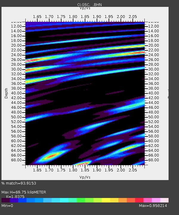
| Estimated Moho Depth: |
69.75 km |
| Estimated Crust Vp/Vs: |
1.84 |
| Assumed Crust Vp: |
6.276 km/s |
| Estimated Crust Vs: |
3.415 km/s |
| Estimated Crust Poisson's Ratio: |
0.29 |
|
| Radial Match: |
93.9153 % |
| Radial Bump: |
400 |
| Transverse Match: |
87.029755 % |
| Transverse Bump: |
400 |
| SOD ConfigId: |
3787 |
| Insert Time: |
2010-02-25 23:46:55.246 +0000 |
| GWidth: |
2.5 |
| Max Bumps: |
400 |
| Tol: |
0.001 |
|
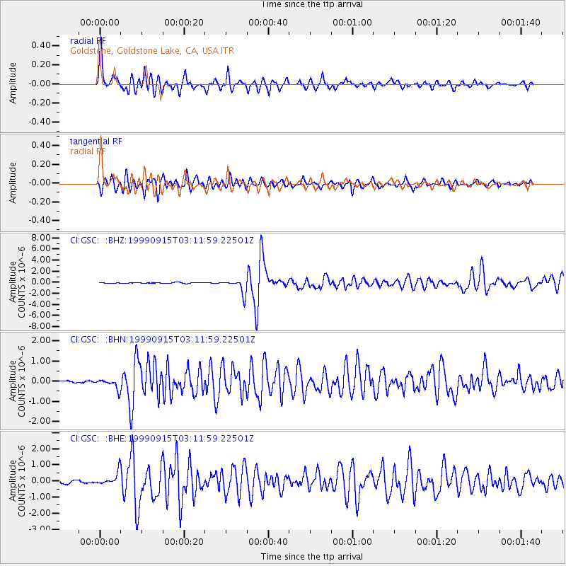
Signal To Noise
| Channel | StoN | STA | LTA |
| CI:GSC: :BHN:19990915T03:11:59.22501Z | 2.5099225 | 2.6860846E-7 | 1.0701863E-7 |
| CI:GSC: :BHE:19990915T03:11:59.22501Z | 3.638826 | 4.403781E-7 | 1.2102203E-7 |
| CI:GSC: :BHZ:19990915T03:11:59.22501Z | 20.821865 | 1.4086166E-6 | 6.7650845E-8 |
| Arrivals |
| Ps | 9.6 SECOND |
| PpPs | 31 SECOND |
| PsPs/PpSs | 40 SECOND |


