You are here: Home > Network List > IU - Global Seismograph Network (GSN - IRIS/USGS) Stations List
> Station COR Corvallis, Oregon, USA > Earthquake Result Viewer
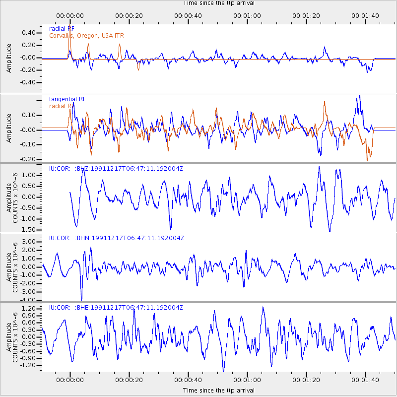
COR Corvallis, Oregon, USA - Earthquake Result Viewer
*The percent match for this event was below the threshold and hence no stack was calculated.
| Earthquake location: |
Kuril Islands |
| Earthquake latitude/longitude: |
47.3/151.5 |
| Earthquake time(UTC): |
1991/12/17 (351) 06:38:16 GMT |
| Earthquake Depth: |
149 km |
| Earthquake Magnitude: |
5.9 MB |
| Earthquake Catalog/Contributor: |
WHDF/NEIC |
|
| Network: |
IU Global Seismograph Network (GSN - IRIS/USGS) |
| Station: |
COR Corvallis, Oregon, USA |
| Lat/Lon: |
44.59 N/123.30 W |
| Elevation: |
121 m |
|
| Distance: |
56.4 deg |
| Az: |
58.776 deg |
| Baz: |
305.53 deg |
| Ray Param: |
$rayparam |
*The percent match for this event was below the threshold and hence was not used in the summary stack. |
|
| Radial Match: |
47.650585 % |
| Radial Bump: |
400 |
| Transverse Match: |
56.616974 % |
| Transverse Bump: |
400 |
| SOD ConfigId: |
4480 |
| Insert Time: |
2010-03-04 20:08:42.191 +0000 |
| GWidth: |
2.5 |
| Max Bumps: |
400 |
| Tol: |
0.001 |
|
Signal To Noise
| Channel | StoN | STA | LTA |
| IU:COR: :BHN:19911217T06:47:11.192004Z | 3.7024672 | 1.2691097E-6 | 3.4277406E-7 |
| IU:COR: :BHE:19911217T06:47:11.192004Z | 0.9643806 | 4.4831376E-7 | 4.6487222E-7 |
| IU:COR: :BHZ:19911217T06:47:11.192004Z | 1.1847534 | 6.377025E-7 | 5.3825755E-7 |
| Arrivals |
| Ps | |
| PpPs | |
| PsPs/PpSs | |


