You are here: Home > Network List > N4 - Central and EAstern US Network Stations List
> Station R49A Shelbyville, KY, USA > Earthquake Result Viewer
R49A Shelbyville, KY, USA - Earthquake Result Viewer
| Earthquake location: |
Off Coast Of Central Chile |
| Earthquake latitude/longitude: |
-29.7/-72.1 |
| Earthquake time(UTC): |
2015/09/19 (262) 05:06:47 GMT |
| Earthquake Depth: |
10 km |
| Earthquake Magnitude: |
5.8 MWR |
| Earthquake Catalog/Contributor: |
NEIC PDE/NEIC COMCAT |
|
| Network: |
N4 Central and EAstern US Network |
| Station: |
R49A Shelbyville, KY, USA |
| Lat/Lon: |
38.29 N/85.17 W |
| Elevation: |
251 m |
|
| Distance: |
68.7 deg |
| Az: |
349.005 deg |
| Baz: |
167.821 deg |
| Ray Param: |
0.05614002 |
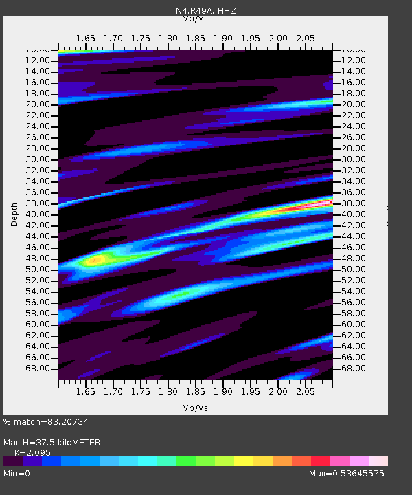
| Estimated Moho Depth: |
37.5 km |
| Estimated Crust Vp/Vs: |
2.10 |
| Assumed Crust Vp: |
6.498 km/s |
| Estimated Crust Vs: |
3.101 km/s |
| Estimated Crust Poisson's Ratio: |
0.35 |
|
| Radial Match: |
83.20734 % |
| Radial Bump: |
400 |
| Transverse Match: |
69.10472 % |
| Transverse Bump: |
400 |
| SOD ConfigId: |
7422571 |
| Insert Time: |
2019-04-20 22:25:23.941 +0000 |
| GWidth: |
2.5 |
| Max Bumps: |
400 |
| Tol: |
0.001 |
|

Signal To Noise
| Channel | StoN | STA | LTA |
| N4:R49A: :HHZ:20150919T05:17:20.440027Z | 6.8628993 | 6.8084506E-7 | 9.920662E-8 |
| N4:R49A: :HHN:20150919T05:17:20.440027Z | 4.6442122 | 3.1273026E-7 | 6.733763E-8 |
| N4:R49A: :HHE:20150919T05:17:20.440027Z | 1.6285652 | 1.02098895E-7 | 6.269254E-8 |
| Arrivals |
| Ps | 6.5 SECOND |
| PpPs | 17 SECOND |
| PsPs/PpSs | 24 SECOND |


