You are here: Home > Network List > TA - USArray Transportable Network (new EarthScope stations) Stations List
> Station O48A Farmland, IN, USA > Earthquake Result Viewer
O48A Farmland, IN, USA - Earthquake Result Viewer
| Earthquake location: |
Off Coast Of Central Chile |
| Earthquake latitude/longitude: |
-29.7/-72.1 |
| Earthquake time(UTC): |
2015/09/19 (262) 05:06:47 GMT |
| Earthquake Depth: |
10 km |
| Earthquake Magnitude: |
5.8 MWR |
| Earthquake Catalog/Contributor: |
NEIC PDE/NEIC COMCAT |
|
| Network: |
TA USArray Transportable Network (new EarthScope stations) |
| Station: |
O48A Farmland, IN, USA |
| Lat/Lon: |
40.26 N/85.16 W |
| Elevation: |
300 m |
|
| Distance: |
70.6 deg |
| Az: |
349.457 deg |
| Baz: |
167.988 deg |
| Ray Param: |
0.054872233 |
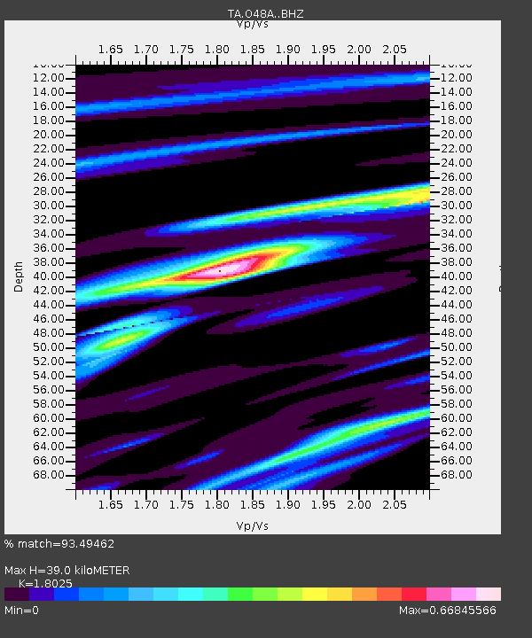
| Estimated Moho Depth: |
39.0 km |
| Estimated Crust Vp/Vs: |
1.80 |
| Assumed Crust Vp: |
6.498 km/s |
| Estimated Crust Vs: |
3.605 km/s |
| Estimated Crust Poisson's Ratio: |
0.28 |
|
| Radial Match: |
93.49462 % |
| Radial Bump: |
283 |
| Transverse Match: |
70.83028 % |
| Transverse Bump: |
400 |
| SOD ConfigId: |
7422571 |
| Insert Time: |
2019-04-20 22:28:27.433 +0000 |
| GWidth: |
2.5 |
| Max Bumps: |
400 |
| Tol: |
0.001 |
|
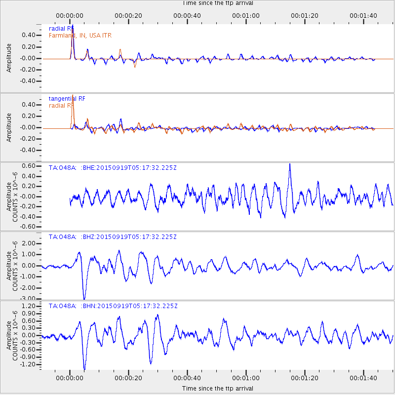
Signal To Noise
| Channel | StoN | STA | LTA |
| TA:O48A: :BHZ:20150919T05:17:32.225Z | 11.745275 | 1.0190021E-6 | 8.675847E-8 |
| TA:O48A: :BHN:20150919T05:17:32.225Z | 4.7115297 | 4.2280385E-7 | 8.973813E-8 |
| TA:O48A: :BHE:20150919T05:17:32.225Z | 1.6626942 | 1.4928528E-7 | 8.9785175E-8 |
| Arrivals |
| Ps | 5.0 SECOND |
| PpPs | 16 SECOND |
| PsPs/PpSs | 21 SECOND |


