You are here: Home > Network List > TA - USArray Transportable Network (new EarthScope stations) Stations List
> Station P60A Greenville, DE, USA > Earthquake Result Viewer
P60A Greenville, DE, USA - Earthquake Result Viewer
| Earthquake location: |
Off Coast Of Central Chile |
| Earthquake latitude/longitude: |
-29.7/-72.1 |
| Earthquake time(UTC): |
2015/09/19 (262) 05:06:47 GMT |
| Earthquake Depth: |
10 km |
| Earthquake Magnitude: |
5.8 MWR |
| Earthquake Catalog/Contributor: |
NEIC PDE/NEIC COMCAT |
|
| Network: |
TA USArray Transportable Network (new EarthScope stations) |
| Station: |
P60A Greenville, DE, USA |
| Lat/Lon: |
39.81 N/75.64 W |
| Elevation: |
105 m |
|
| Distance: |
69.2 deg |
| Az: |
357.105 deg |
| Baz: |
176.728 deg |
| Ray Param: |
0.055811036 |
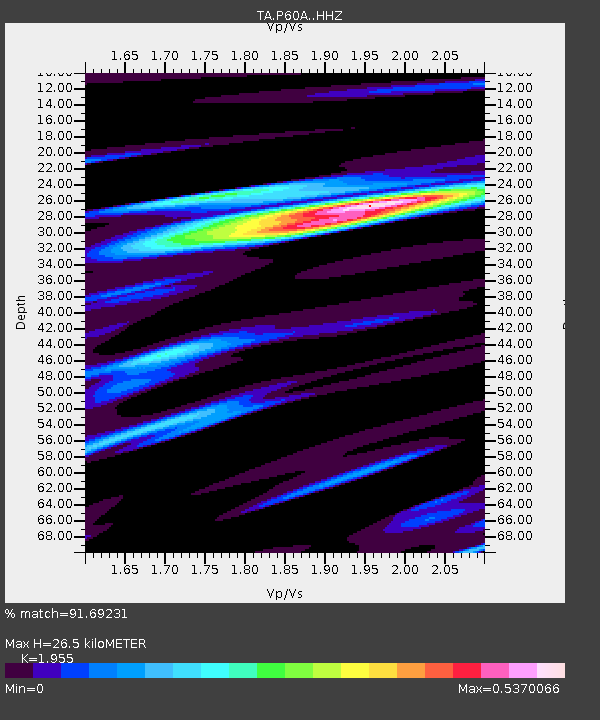
| Estimated Moho Depth: |
26.5 km |
| Estimated Crust Vp/Vs: |
1.96 |
| Assumed Crust Vp: |
6.287 km/s |
| Estimated Crust Vs: |
3.216 km/s |
| Estimated Crust Poisson's Ratio: |
0.32 |
|
| Radial Match: |
91.69231 % |
| Radial Bump: |
360 |
| Transverse Match: |
76.387794 % |
| Transverse Bump: |
400 |
| SOD ConfigId: |
7422571 |
| Insert Time: |
2019-04-20 22:28:33.120 +0000 |
| GWidth: |
2.5 |
| Max Bumps: |
400 |
| Tol: |
0.001 |
|

Signal To Noise
| Channel | StoN | STA | LTA |
| TA:P60A: :HHZ:20150919T05:17:23.519983Z | 11.882846 | 5.72067E-7 | 4.8142255E-8 |
| TA:P60A: :HHN:20150919T05:17:23.519983Z | 3.4155595 | 2.3786163E-7 | 6.9640606E-8 |
| TA:P60A: :HHE:20150919T05:17:23.519983Z | 1.2217597 | 1.1314923E-7 | 9.2611685E-8 |
| Arrivals |
| Ps | 4.2 SECOND |
| PpPs | 12 SECOND |
| PsPs/PpSs | 16 SECOND |


