You are here: Home > Network List > US - United States National Seismic Network Stations List
> Station WRAK Wrangell Island, Southeastern Alaska, Alaska, USA > Earthquake Result Viewer
WRAK Wrangell Island, Southeastern Alaska, Alaska, USA - Earthquake Result Viewer
| Earthquake location: |
Near East Coast Of Honshu, Japan |
| Earthquake latitude/longitude: |
38.9/142.0 |
| Earthquake time(UTC): |
2015/05/12 (132) 21:12:58 GMT |
| Earthquake Depth: |
39 km |
| Earthquake Magnitude: |
6.8 MWP, 6.8 MI |
| Earthquake Catalog/Contributor: |
NEIC PDE/NEIC COMCAT |
|
| Network: |
US United States National Seismic Network |
| Station: |
WRAK Wrangell Island, Southeastern Alaska, Alaska, USA |
| Lat/Lon: |
56.42 N/132.35 W |
| Elevation: |
81 m |
|
| Distance: |
56.4 deg |
| Az: |
41.686 deg |
| Baz: |
290.96 deg |
| Ray Param: |
0.06407487 |
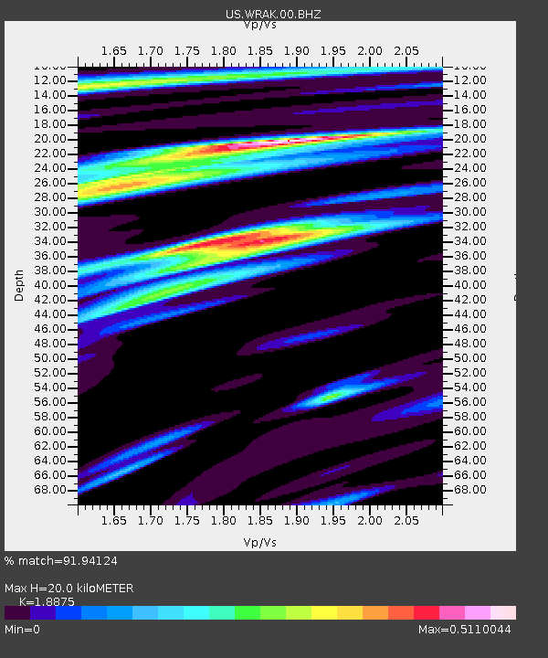
| Estimated Moho Depth: |
20.0 km |
| Estimated Crust Vp/Vs: |
1.89 |
| Assumed Crust Vp: |
6.597 km/s |
| Estimated Crust Vs: |
3.495 km/s |
| Estimated Crust Poisson's Ratio: |
0.30 |
|
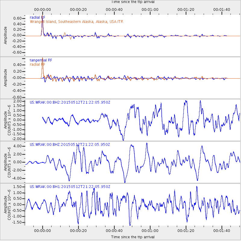
| Radial Match: |
91.94124 % |
| Radial Bump: |
285 |
| Transverse Match: |
62.546646 % |
| Transverse Bump: |
400 |
| SOD ConfigId: |
976571 |
| Insert Time: |
2015-05-26 21:44:06.028 +0000 |
| GWidth: |
2.5 |
| Max Bumps: |
400 |
| Tol: |
0.001 |
|
Signal To Noise
| Channel | StoN | STA | LTA |
| US:WRAK:00:BHZ:20150512T21:22:05.950Z | 2.4537823 | 8.149106E-7 | 3.3210387E-7 |
| US:WRAK:00:BH1:20150512T21:22:05.950Z | 1.7487386 | 3.429607E-7 | 1.9611892E-7 |
| US:WRAK:00:BH2:20150512T21:22:05.950Z | 1.6064178 | 3.9106783E-7 | 2.4344092E-7 |
| Arrivals |
| Ps | 2.8 SECOND |
| PpPs | 8.3 SECOND |
| PsPs/PpSs | 11 SECOND |


