You are here: Home > Network List > 7A - Mid-Atlantic Geophysical Integrative Collaboration Stations List
> Station BARB Louisa, Virginia USA > Earthquake Result Viewer
BARB Louisa, Virginia USA - Earthquake Result Viewer
| Earthquake location: |
Near Coast Of Central Chile |
| Earthquake latitude/longitude: |
-31.1/-71.6 |
| Earthquake time(UTC): |
2015/09/19 (262) 09:07:08 GMT |
| Earthquake Depth: |
23 km |
| Earthquake Magnitude: |
6.1 MWP |
| Earthquake Catalog/Contributor: |
NEIC PDE/NEIC COMCAT |
|
| Network: |
7A Mid-Atlantic Geophysical Integrative Collaboration |
| Station: |
BARB Louisa, Virginia USA |
| Lat/Lon: |
37.99 N/78.09 W |
| Elevation: |
84 m |
|
| Distance: |
69.0 deg |
| Az: |
354.525 deg |
| Baz: |
174.055 deg |
| Ray Param: |
0.055901866 |
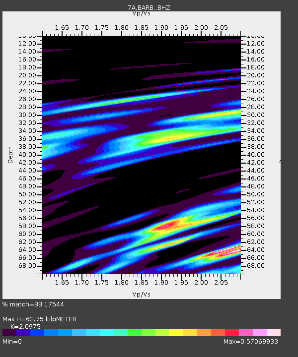
| Estimated Moho Depth: |
63.75 km |
| Estimated Crust Vp/Vs: |
2.10 |
| Assumed Crust Vp: |
6.419 km/s |
| Estimated Crust Vs: |
3.06 km/s |
| Estimated Crust Poisson's Ratio: |
0.35 |
|
| Radial Match: |
88.17544 % |
| Radial Bump: |
400 |
| Transverse Match: |
56.016148 % |
| Transverse Bump: |
400 |
| SOD ConfigId: |
7422571 |
| Insert Time: |
2019-04-20 22:33:00.282 +0000 |
| GWidth: |
2.5 |
| Max Bumps: |
400 |
| Tol: |
0.001 |
|

Signal To Noise
| Channel | StoN | STA | LTA |
| 7A:BARB: :BHZ:20150919T09:17:40.790007Z | 9.468836 | 1.2549755E-6 | 1.3253747E-7 |
| 7A:BARB: :BHN:20150919T09:17:40.790007Z | 10.408872 | 7.7484157E-7 | 7.444049E-8 |
| 7A:BARB: :BHE:20150919T09:17:40.790007Z | 2.2377946 | 1.8202196E-7 | 8.133989E-8 |
| Arrivals |
| Ps | 11 SECOND |
| PpPs | 30 SECOND |
| PsPs/PpSs | 41 SECOND |


