You are here: Home > Network List > 7A - Mid-Atlantic Geophysical Integrative Collaboration Stations List
> Station BDEG Charles Lake, Virginia USA > Earthquake Result Viewer
BDEG Charles Lake, Virginia USA - Earthquake Result Viewer
| Earthquake location: |
Near Coast Of Central Chile |
| Earthquake latitude/longitude: |
-31.1/-71.6 |
| Earthquake time(UTC): |
2015/09/19 (262) 09:07:08 GMT |
| Earthquake Depth: |
23 km |
| Earthquake Magnitude: |
6.1 MWP |
| Earthquake Catalog/Contributor: |
NEIC PDE/NEIC COMCAT |
|
| Network: |
7A Mid-Atlantic Geophysical Integrative Collaboration |
| Station: |
BDEG Charles Lake, Virginia USA |
| Lat/Lon: |
37.33 N/77.21 W |
| Elevation: |
-21.0 m |
|
| Distance: |
68.3 deg |
| Az: |
355.2 deg |
| Baz: |
174.834 deg |
| Ray Param: |
0.05637426 |
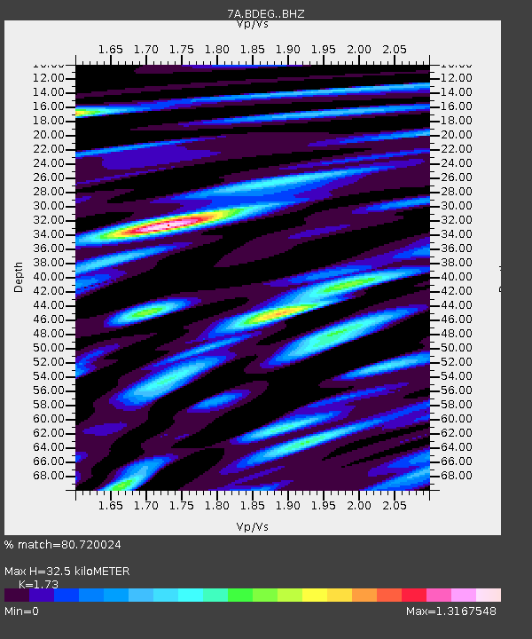
| Estimated Moho Depth: |
32.5 km |
| Estimated Crust Vp/Vs: |
1.73 |
| Assumed Crust Vp: |
6.565 km/s |
| Estimated Crust Vs: |
3.795 km/s |
| Estimated Crust Poisson's Ratio: |
0.25 |
|
| Radial Match: |
80.720024 % |
| Radial Bump: |
400 |
| Transverse Match: |
63.869793 % |
| Transverse Bump: |
400 |
| SOD ConfigId: |
7422571 |
| Insert Time: |
2019-04-20 22:33:00.235 +0000 |
| GWidth: |
2.5 |
| Max Bumps: |
400 |
| Tol: |
0.001 |
|

Signal To Noise
| Channel | StoN | STA | LTA |
| 7A:BDEG: :BHZ:20150919T09:17:36.314971Z | 10.099988 | 1.0210388E-6 | 1.01093065E-7 |
| 7A:BDEG: :BHN:20150919T09:17:36.314971Z | 4.22585 | 6.427861E-7 | 1.5210811E-7 |
| 7A:BDEG: :BHE:20150919T09:17:36.314971Z | 1.1831143 | 1.5098445E-7 | 1.2761612E-7 |
| Arrivals |
| Ps | 3.8 SECOND |
| PpPs | 13 SECOND |
| PsPs/PpSs | 17 SECOND |


