You are here: Home > Network List > UU - University of Utah Regional Network Stations List
> Station ASI2 Darling Creek, Challis, ID, USA > Earthquake Result Viewer
ASI2 Darling Creek, Challis, ID, USA - Earthquake Result Viewer
| Earthquake location: |
Near East Coast Of Honshu, Japan |
| Earthquake latitude/longitude: |
38.9/142.0 |
| Earthquake time(UTC): |
2015/05/12 (132) 21:12:58 GMT |
| Earthquake Depth: |
39 km |
| Earthquake Magnitude: |
6.8 MWP, 6.8 MI |
| Earthquake Catalog/Contributor: |
NEIC PDE/NEIC COMCAT |
|
| Network: |
UU University of Utah Regional Network |
| Station: |
ASI2 Darling Creek, Challis, ID, USA |
| Lat/Lon: |
44.57 N/114.26 W |
| Elevation: |
1600 m |
|
| Distance: |
72.2 deg |
| Az: |
46.814 deg |
| Baz: |
307.246 deg |
| Ray Param: |
0.05373731 |
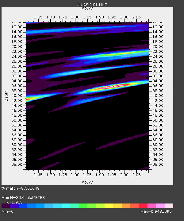
| Estimated Moho Depth: |
36.0 km |
| Estimated Crust Vp/Vs: |
1.96 |
| Assumed Crust Vp: |
6.577 km/s |
| Estimated Crust Vs: |
3.364 km/s |
| Estimated Crust Poisson's Ratio: |
0.32 |
|
| Radial Match: |
87.01049 % |
| Radial Bump: |
400 |
| Transverse Match: |
76.77364 % |
| Transverse Bump: |
400 |
| SOD ConfigId: |
976571 |
| Insert Time: |
2015-05-26 21:47:37.773 +0000 |
| GWidth: |
2.5 |
| Max Bumps: |
400 |
| Tol: |
0.001 |
|

Signal To Noise
| Channel | StoN | STA | LTA |
| UU:ASI2:01:HHZ:20150512T21:23:49.119006Z | 9.2512045 | 2.2539407E-8 | 2.4363755E-9 |
| UU:ASI2:01:HHN:20150512T21:23:49.119006Z | 2.2754285 | 7.678353E-9 | 3.374465E-9 |
| UU:ASI2:01:HHE:20150512T21:23:49.119006Z | 1.1919899 | 1.39580685E-8 | 1.1709889E-8 |
| Arrivals |
| Ps | 5.4 SECOND |
| PpPs | 16 SECOND |
| PsPs/PpSs | 21 SECOND |


