You are here: Home > Network List > LD - Lamont-Doherty Cooperative Seismographic Network Stations List
> Station WUPA West Chester University of Pennsylvania > Earthquake Result Viewer
WUPA West Chester University of Pennsylvania - Earthquake Result Viewer
| Earthquake location: |
Near Coast Of Central Chile |
| Earthquake latitude/longitude: |
-31.1/-71.6 |
| Earthquake time(UTC): |
2015/09/19 (262) 09:07:08 GMT |
| Earthquake Depth: |
23 km |
| Earthquake Magnitude: |
6.1 MWP |
| Earthquake Catalog/Contributor: |
NEIC PDE/NEIC COMCAT |
|
| Network: |
LD Lamont-Doherty Cooperative Seismographic Network |
| Station: |
WUPA West Chester University of Pennsylvania |
| Lat/Lon: |
39.93 N/75.61 W |
| Elevation: |
86 m |
|
| Distance: |
70.8 deg |
| Az: |
356.748 deg |
| Baz: |
176.372 deg |
| Ray Param: |
0.054728325 |
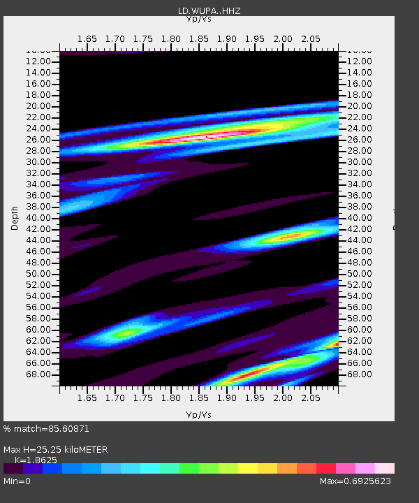
| Estimated Moho Depth: |
25.25 km |
| Estimated Crust Vp/Vs: |
1.86 |
| Assumed Crust Vp: |
6.287 km/s |
| Estimated Crust Vs: |
3.376 km/s |
| Estimated Crust Poisson's Ratio: |
0.30 |
|
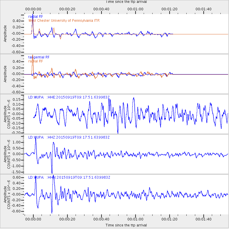
| Radial Match: |
85.60871 % |
| Radial Bump: |
301 |
| Transverse Match: |
64.75724 % |
| Transverse Bump: |
400 |
| SOD ConfigId: |
7422571 |
| Insert Time: |
2019-04-20 22:36:24.605 +0000 |
| GWidth: |
2.5 |
| Max Bumps: |
400 |
| Tol: |
0.001 |
|
Signal To Noise
| Channel | StoN | STA | LTA |
| LD:WUPA: :HHZ:20150919T09:17:51.639983Z | 9.982731 | 5.125508E-7 | 5.1343743E-8 |
| LD:WUPA: :HHN:20150919T09:17:51.639983Z | 5.5106387 | 2.7060318E-7 | 4.9105594E-8 |
| LD:WUPA: :HHE:20150919T09:17:51.639983Z | 1.387379 | 7.1694835E-8 | 5.167646E-8 |
| Arrivals |
| Ps | 3.6 SECOND |
| PpPs | 11 SECOND |
| PsPs/PpSs | 15 SECOND |


