You are here: Home > Network List > IU - Global Seismograph Network (GSN - IRIS/USGS) Stations List
> Station HNR Honiara, Solomon Islands > Earthquake Result Viewer
HNR Honiara, Solomon Islands - Earthquake Result Viewer
| Earthquake location: |
Hokkaido, Japan Region |
| Earthquake latitude/longitude: |
42.9/145.2 |
| Earthquake time(UTC): |
2004/12/06 (341) 14:15:11 GMT |
| Earthquake Depth: |
35 km |
| Earthquake Magnitude: |
6.5 MB, 6.5 MS, 6.8 MW, 6.8 MW |
| Earthquake Catalog/Contributor: |
WHDF/NEIC |
|
| Network: |
IU Global Seismograph Network (GSN - IRIS/USGS) |
| Station: |
HNR Honiara, Solomon Islands |
| Lat/Lon: |
9.43 S/159.95 E |
| Elevation: |
72 m |
|
| Distance: |
53.8 deg |
| Az: |
161.898 deg |
| Baz: |
346.62 deg |
| Ray Param: |
0.06579786 |
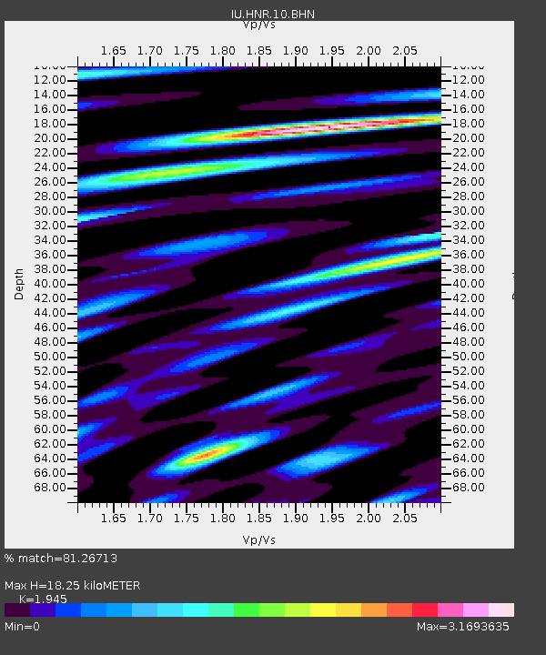
| Estimated Moho Depth: |
18.25 km |
| Estimated Crust Vp/Vs: |
1.95 |
| Assumed Crust Vp: |
6.183 km/s |
| Estimated Crust Vs: |
3.179 km/s |
| Estimated Crust Poisson's Ratio: |
0.32 |
|
| Radial Match: |
81.26713 % |
| Radial Bump: |
400 |
| Transverse Match: |
76.40705 % |
| Transverse Bump: |
400 |
| SOD ConfigId: |
2459 |
| Insert Time: |
2010-03-04 20:12:56.520 +0000 |
| GWidth: |
2.5 |
| Max Bumps: |
400 |
| Tol: |
0.001 |
|
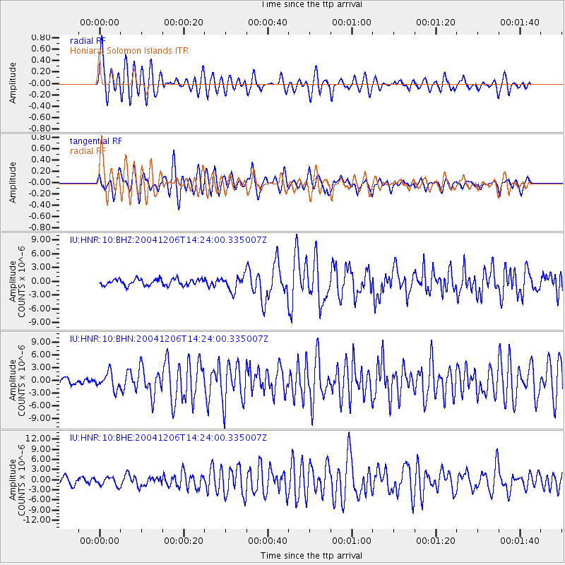
Signal To Noise
| Channel | StoN | STA | LTA |
| IU:HNR:10:BHN:20041206T14:24:00.335007Z | 2.2579815 | 1.9388633E-6 | 8.58671E-7 |
| IU:HNR:10:BHE:20041206T14:24:00.335007Z | 1.3528105 | 1.22335E-6 | 9.0430257E-7 |
| IU:HNR:10:BHZ:20041206T14:24:00.335007Z | 2.3595865 | 1.6265985E-6 | 6.893575E-7 |
| Arrivals |
| Ps | 2.9 SECOND |
| PpPs | 8.3 SECOND |
| PsPs/PpSs | 11 SECOND |


