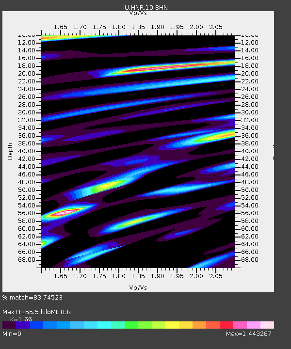
HNR Honiara, Solomon Islands - Earthquake Result Viewer
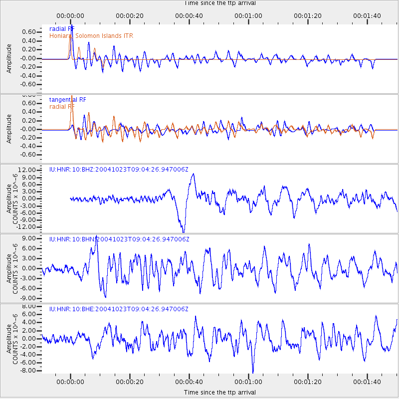
Earthquake location: Near West Coast Of Honshu, Japan
Earthquake latitude/longitude: 37.2/138.8
Earthquake time(UTC): 2004/10/23 (297) 08:56:00 GMT
Earthquake Depth: 16 km
Earthquake Magnitude: 6.4 MB, 6.3 MS, 6.6 MW, 6.4 MW
Earthquake Catalog/Contributor: WHDF/NEIC
Network: IU Global Seismograph Network (GSN - IRIS/USGS)
Station: HNR Honiara, Solomon Islands
Lat/Lon: 9.43 S/159.95 E
Elevation: 72 m
Distance: 50.5 deg
Az: 152.492 deg
Baz: 338.059 deg
Ray Param: 0.06801327
Estimated Moho Depth: 55.5 km
Estimated Crust Vp/Vs: 1.66
Assumed Crust Vp: 6.183 km/s
Estimated Crust Vs: 3.724 km/s
Estimated Crust Poisson's Ratio: 0.22
Radial Match: 83.74523 %
Radial Bump: 400
Transverse Match: 83.275795 %
Transverse Bump: 400
SOD ConfigId: 2459
Insert Time: 2010-03-04 20:12:58.010 +0000
GWidth: 2.5
Max Bumps: 400
Tol: 0.001

Signal To Noise

ChannelStoNSTALTA
IU:HNR:10:BHN:20041023T09:04:26.947006Z2.5618681.5288786E-65.9678274E-7
IU:HNR:10:BHE:20041023T09:04:26.947006Z1.31123019.2499346E-77.0543945E-7
IU:HNR:10:BHZ:20041023T09:04:26.947006Z3.07998322.1956241E-67.128689E-7
Arrivals
Ps6.3 SECOND
PpPs23 SECOND
PsPs/PpSs29 SECOND