You are here: Home > Network List > IU - Global Seismograph Network (GSN - IRIS/USGS) Stations List
> Station HNR Honiara, Solomon Islands > Earthquake Result Viewer
HNR Honiara, Solomon Islands - Earthquake Result Viewer
| Earthquake location: |
Southern Molucca Sea |
| Earthquake latitude/longitude: |
-0.1/124.7 |
| Earthquake time(UTC): |
2005/12/21 (355) 07:09:05 GMT |
| Earthquake Depth: |
25 km |
| Earthquake Magnitude: |
6.3 MB, 5.9 MS, 6.3 MW, 6.2 MW |
| Earthquake Catalog/Contributor: |
WHDF/NEIC |
|
| Network: |
IU Global Seismograph Network (GSN - IRIS/USGS) |
| Station: |
HNR Honiara, Solomon Islands |
| Lat/Lon: |
9.43 S/159.95 E |
| Elevation: |
72 m |
|
| Distance: |
36.3 deg |
| Az: |
105.861 deg |
| Baz: |
282.855 deg |
| Ray Param: |
0.07670412 |
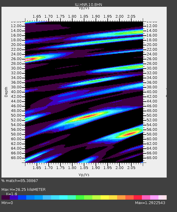
| Estimated Moho Depth: |
26.25 km |
| Estimated Crust Vp/Vs: |
1.60 |
| Assumed Crust Vp: |
6.183 km/s |
| Estimated Crust Vs: |
3.864 km/s |
| Estimated Crust Poisson's Ratio: |
0.18 |
|
| Radial Match: |
85.38867 % |
| Radial Bump: |
400 |
| Transverse Match: |
82.81379 % |
| Transverse Bump: |
400 |
| SOD ConfigId: |
2422 |
| Insert Time: |
2010-03-04 20:13:01.697 +0000 |
| GWidth: |
2.5 |
| Max Bumps: |
400 |
| Tol: |
0.001 |
|
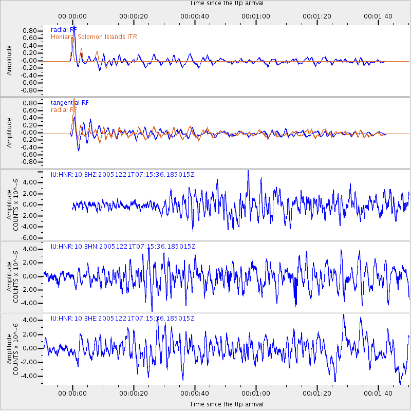
Signal To Noise
| Channel | StoN | STA | LTA |
| IU:HNR:10:BHN:20051221T07:15:36.185015Z | 1.589496 | 7.91028E-7 | 4.9765964E-7 |
| IU:HNR:10:BHE:20051221T07:15:36.185015Z | 2.0142326 | 1.1121756E-6 | 5.5215844E-7 |
| IU:HNR:10:BHZ:20051221T07:15:36.185015Z | 2.5744767 | 1.1722224E-6 | 4.5532448E-7 |
| Arrivals |
| Ps | 2.8 SECOND |
| PpPs | 10 SECOND |
| PsPs/PpSs | 13 SECOND |


