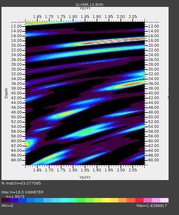
HNR Honiara, Solomon Islands - Earthquake Result Viewer
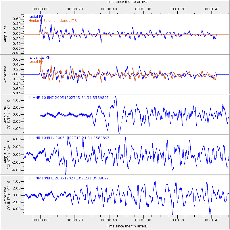
Earthquake location: Near East Coast Of Honshu, Japan
Earthquake latitude/longitude: 38.1/142.1
Earthquake time(UTC): 2005/12/02 (336) 13:13:09 GMT
Earthquake Depth: 29 km
Earthquake Magnitude: 6.1 MB, 6.3 MS, 6.5 MW, 6.4 MW
Earthquake Catalog/Contributor: WHDF/NEIC
Network: IU Global Seismograph Network (GSN - IRIS/USGS)
Station: HNR Honiara, Solomon Islands
Lat/Lon: 9.43 S/159.95 E
Elevation: 72 m
Distance: 50.1 deg
Az: 156.824 deg
Baz: 341.655 deg
Ray Param: 0.06821403
Estimated Moho Depth: 18.0 km
Estimated Crust Vp/Vs: 1.96
Assumed Crust Vp: 6.183 km/s
Estimated Crust Vs: 3.158 km/s
Estimated Crust Poisson's Ratio: 0.32
Radial Match: 83.077065 %
Radial Bump: 400
Transverse Match: 77.74946 %
Transverse Bump: 400
SOD ConfigId: 2422
Insert Time: 2010-03-04 20:13:03.423 +0000
GWidth: 2.5
Max Bumps: 400
Tol: 0.001

Signal To Noise

ChannelStoNSTALTA
IU:HNR:10:BHN:20051202T13:21:31.358989Z1.82513081.0227233E-65.603561E-7
IU:HNR:10:BHE:20051202T13:21:31.358989Z1.18830656.332681E-75.3291643E-7
IU:HNR:10:BHZ:20051202T13:21:31.358989Z5.5869051.6560342E-62.964135E-7
Arrivals
Ps2.9 SECOND
PpPs8.2 SECOND
PsPs/PpSs11 SECOND