You are here: Home > Network List > IU - Global Seismograph Network (GSN - IRIS/USGS) Stations List
> Station HNR Honiara, Solomon Islands > Earthquake Result Viewer
HNR Honiara, Solomon Islands - Earthquake Result Viewer
| Earthquake location: |
Pacific-Antarctic Ridge |
| Earthquake latitude/longitude: |
-57.4/-139.2 |
| Earthquake time(UTC): |
2005/05/12 (132) 11:15:35 GMT |
| Earthquake Depth: |
10 km |
| Earthquake Magnitude: |
6.0 MB, 6.2 MS, 6.5 MW, 6.4 MW |
| Earthquake Catalog/Contributor: |
WHDF/NEIC |
|
| Network: |
IU Global Seismograph Network (GSN - IRIS/USGS) |
| Station: |
HNR Honiara, Solomon Islands |
| Lat/Lon: |
9.43 S/159.95 E |
| Elevation: |
72 m |
|
| Distance: |
66.6 deg |
| Az: |
290.155 deg |
| Baz: |
148.981 deg |
| Ray Param: |
0.057519156 |
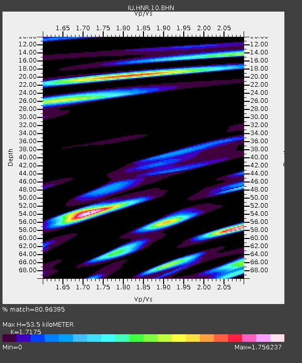
| Estimated Moho Depth: |
53.5 km |
| Estimated Crust Vp/Vs: |
1.72 |
| Assumed Crust Vp: |
6.183 km/s |
| Estimated Crust Vs: |
3.6 km/s |
| Estimated Crust Poisson's Ratio: |
0.24 |
|
| Radial Match: |
80.96395 % |
| Radial Bump: |
400 |
| Transverse Match: |
81.941826 % |
| Transverse Bump: |
400 |
| SOD ConfigId: |
2455 |
| Insert Time: |
2010-03-04 20:13:10.081 +0000 |
| GWidth: |
2.5 |
| Max Bumps: |
400 |
| Tol: |
0.001 |
|
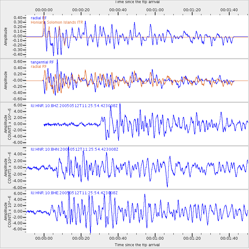
Signal To Noise
| Channel | StoN | STA | LTA |
| IU:HNR:10:BHN:20050512T11:25:54.423008Z | 1.4497372 | 4.3758493E-7 | 3.0183742E-7 |
| IU:HNR:10:BHE:20050512T11:25:54.423008Z | 2.7314534 | 9.100072E-7 | 3.331586E-7 |
| IU:HNR:10:BHZ:20050512T11:25:54.423008Z | 8.284368 | 2.0915763E-6 | 2.5247266E-7 |
| Arrivals |
| Ps | 6.5 SECOND |
| PpPs | 23 SECOND |
| PsPs/PpSs | 29 SECOND |


