You are here: Home > Network List > IU - Global Seismograph Network (GSN - IRIS/USGS) Stations List
> Station HNR Honiara, Solomon Islands > Earthquake Result Viewer
HNR Honiara, Solomon Islands - Earthquake Result Viewer
| Earthquake location: |
Kuril Islands |
| Earthquake latitude/longitude: |
43.9/146.1 |
| Earthquake time(UTC): |
2005/09/21 (264) 02:25:08 GMT |
| Earthquake Depth: |
103 km |
| Earthquake Magnitude: |
6.0 MB, 6.1 MW, 6.0 MW |
| Earthquake Catalog/Contributor: |
WHDF/NEIC |
|
| Network: |
IU Global Seismograph Network (GSN - IRIS/USGS) |
| Station: |
HNR Honiara, Solomon Islands |
| Lat/Lon: |
9.43 S/159.95 E |
| Elevation: |
72 m |
|
| Distance: |
54.5 deg |
| Az: |
163.201 deg |
| Baz: |
347.774 deg |
| Ray Param: |
0.06507179 |
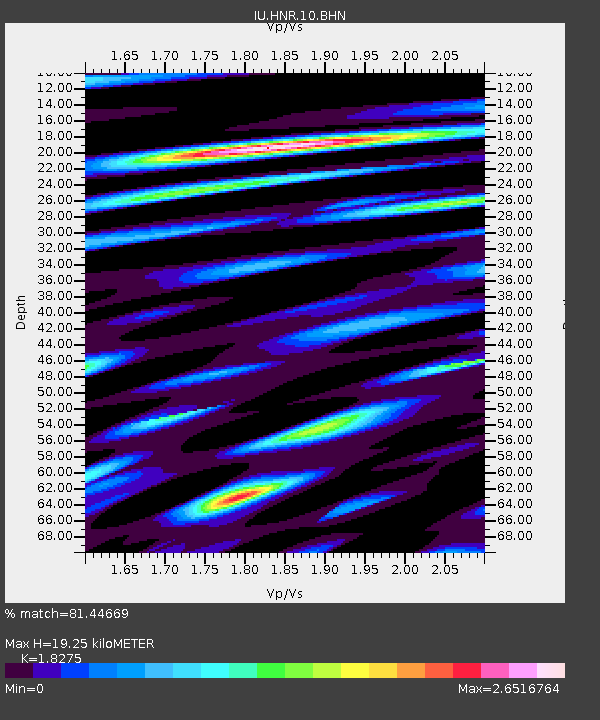
| Estimated Moho Depth: |
19.25 km |
| Estimated Crust Vp/Vs: |
1.83 |
| Assumed Crust Vp: |
6.183 km/s |
| Estimated Crust Vs: |
3.383 km/s |
| Estimated Crust Poisson's Ratio: |
0.29 |
|
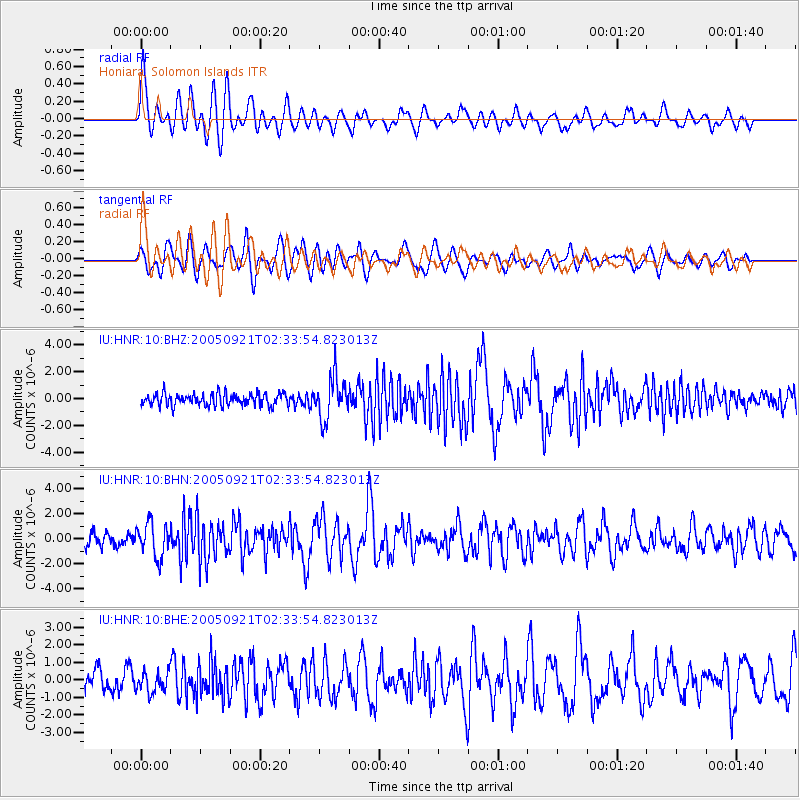
| Radial Match: |
81.44669 % |
| Radial Bump: |
400 |
| Transverse Match: |
77.55055 % |
| Transverse Bump: |
400 |
| SOD ConfigId: |
2475 |
| Insert Time: |
2010-03-04 20:13:12.920 +0000 |
| GWidth: |
2.5 |
| Max Bumps: |
400 |
| Tol: |
0.001 |
|
Signal To Noise
| Channel | StoN | STA | LTA |
| IU:HNR:10:BHN:20050921T02:33:54.823013Z | 2.511895 | 1.3232592E-6 | 5.267972E-7 |
| IU:HNR:10:BHE:20050921T02:33:54.823013Z | 1.1394765 | 6.0223965E-7 | 5.2852306E-7 |
| IU:HNR:10:BHZ:20050921T02:33:54.823013Z | 3.4504309 | 1.5342042E-6 | 4.4464136E-7 |
| Arrivals |
| Ps | 2.7 SECOND |
| PpPs | 8.4 SECOND |
| PsPs/PpSs | 11 SECOND |


