You are here: Home > Network List > IU - Global Seismograph Network (GSN - IRIS/USGS) Stations List
> Station HNR Honiara, Solomon Islands > Earthquake Result Viewer
HNR Honiara, Solomon Islands - Earthquake Result Viewer
| Earthquake location: |
Banda Sea |
| Earthquake latitude/longitude: |
-5.5/128.1 |
| Earthquake time(UTC): |
2006/01/27 (027) 16:58:53 GMT |
| Earthquake Depth: |
397 km |
| Earthquake Magnitude: |
7.0 MB, 7.6 MW, 7.5 MW |
| Earthquake Catalog/Contributor: |
WHDF/NEIC |
|
| Network: |
IU Global Seismograph Network (GSN - IRIS/USGS) |
| Station: |
HNR Honiara, Solomon Islands |
| Lat/Lon: |
9.43 S/159.95 E |
| Elevation: |
72 m |
|
| Distance: |
31.8 deg |
| Az: |
99.028 deg |
| Baz: |
274.819 deg |
| Ray Param: |
0.077451915 |
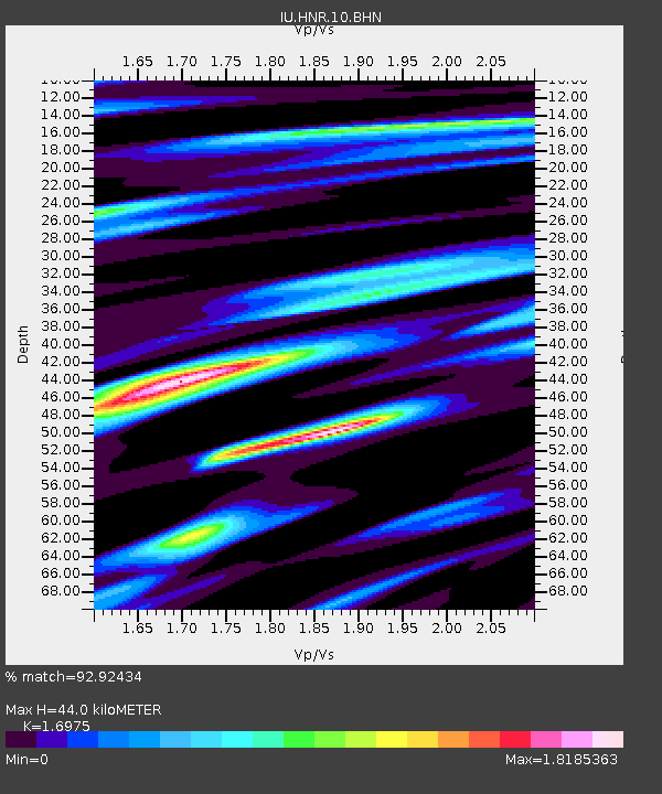
| Estimated Moho Depth: |
44.0 km |
| Estimated Crust Vp/Vs: |
1.70 |
| Assumed Crust Vp: |
6.183 km/s |
| Estimated Crust Vs: |
3.642 km/s |
| Estimated Crust Poisson's Ratio: |
0.23 |
|
| Radial Match: |
92.92434 % |
| Radial Bump: |
381 |
| Transverse Match: |
92.456894 % |
| Transverse Bump: |
400 |
| SOD ConfigId: |
4977 |
| Insert Time: |
2010-03-04 20:13:16.825 +0000 |
| GWidth: |
2.5 |
| Max Bumps: |
400 |
| Tol: |
0.001 |
|
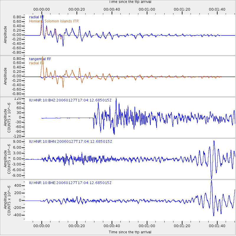
Signal To Noise
| Channel | StoN | STA | LTA |
| IU:HNR:10:BHN:20060127T17:04:12.685015Z | 43.617195 | 7.0437653E-7 | 1.6149055E-8 |
| IU:HNR:10:BHE:20060127T17:04:12.685015Z | 37.113316 | 2.5115984E-5 | 6.7673784E-7 |
| IU:HNR:10:BHZ:20060127T17:04:12.685015Z | 50.24757 | 4.2811036E-5 | 8.5200213E-7 |
| Arrivals |
| Ps | 5.3 SECOND |
| PpPs | 18 SECOND |
| PsPs/PpSs | 23 SECOND |


