You are here: Home > Network List > IU - Global Seismograph Network (GSN - IRIS/USGS) Stations List
> Station CTAO Charters Towers, Australia > Earthquake Result Viewer
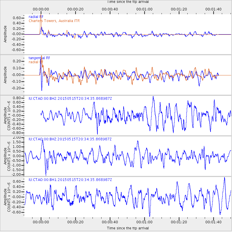
CTAO Charters Towers, Australia - Earthquake Result Viewer
*The percent match for this event was below the threshold and hence no stack was calculated.
| Earthquake location: |
Southern Sumatra, Indonesia |
| Earthquake latitude/longitude: |
-2.6/102.2 |
| Earthquake time(UTC): |
2015/05/15 (135) 20:26:55 GMT |
| Earthquake Depth: |
151 km |
| Earthquake Magnitude: |
6.0 MWW, 6.0 MWB, 6.0 MWC |
| Earthquake Catalog/Contributor: |
NEIC PDE/NEIC COMCAT |
|
| Network: |
IU Global Seismograph Network (GSN - IRIS/USGS) |
| Station: |
CTAO Charters Towers, Australia |
| Lat/Lon: |
20.09 S/146.25 E |
| Elevation: |
357 m |
|
| Distance: |
46.4 deg |
| Az: |
115.382 deg |
| Baz: |
286.212 deg |
| Ray Param: |
$rayparam |
*The percent match for this event was below the threshold and hence was not used in the summary stack. |
|
| Radial Match: |
66.29728 % |
| Radial Bump: |
400 |
| Transverse Match: |
61.049526 % |
| Transverse Bump: |
400 |
| SOD ConfigId: |
976571 |
| Insert Time: |
2015-05-29 20:56:16.003 +0000 |
| GWidth: |
2.5 |
| Max Bumps: |
400 |
| Tol: |
0.001 |
|
Signal To Noise
| Channel | StoN | STA | LTA |
| IU:CTAO:00:BHZ:20150515T20:34:35.868987Z | 2.2594326 | 9.944127E-7 | 4.4011617E-7 |
| IU:CTAO:00:BH1:20150515T20:34:35.868987Z | 0.60473096 | 1.4820912E-7 | 2.4508273E-7 |
| IU:CTAO:00:BH2:20150515T20:34:35.868987Z | 2.013845 | 3.6065455E-7 | 1.7908755E-7 |
| Arrivals |
| Ps | |
| PpPs | |
| PsPs/PpSs | |


