You are here: Home > Network List > TA - USArray Transportable Network (new EarthScope stations) Stations List
> Station J61A Chester, VT, USA > Earthquake Result Viewer
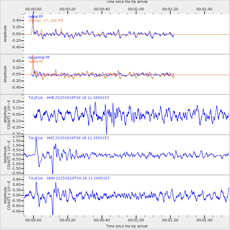
J61A Chester, VT, USA - Earthquake Result Viewer
*The percent match for this event was below the threshold and hence no stack was calculated.
| Earthquake location: |
Near Coast Of Central Chile |
| Earthquake latitude/longitude: |
-31.1/-71.6 |
| Earthquake time(UTC): |
2015/09/19 (262) 09:07:08 GMT |
| Earthquake Depth: |
23 km |
| Earthquake Magnitude: |
6.1 MWP |
| Earthquake Catalog/Contributor: |
NEIC PDE/NEIC COMCAT |
|
| Network: |
TA USArray Transportable Network (new EarthScope stations) |
| Station: |
J61A Chester, VT, USA |
| Lat/Lon: |
43.35 N/72.55 W |
| Elevation: |
253 m |
|
| Distance: |
74.1 deg |
| Az: |
359.285 deg |
| Baz: |
179.16 deg |
| Ray Param: |
$rayparam |
*The percent match for this event was below the threshold and hence was not used in the summary stack. |
|
| Radial Match: |
64.84536 % |
| Radial Bump: |
400 |
| Transverse Match: |
62.93032 % |
| Transverse Bump: |
400 |
| SOD ConfigId: |
7422571 |
| Insert Time: |
2019-04-20 22:41:07.719 +0000 |
| GWidth: |
2.5 |
| Max Bumps: |
400 |
| Tol: |
0.001 |
|
Signal To Noise
| Channel | StoN | STA | LTA |
| TA:J61A: :HHZ:20150919T09:18:11.360015Z | 7.242865 | 7.379707E-7 | 1.01889334E-7 |
| TA:J61A: :HHN:20150919T09:18:11.360015Z | 3.8902736 | 3.0822915E-7 | 7.9230716E-8 |
| TA:J61A: :HHE:20150919T09:18:11.360015Z | 1.3825598 | 7.0609524E-8 | 5.107159E-8 |
| Arrivals |
| Ps | |
| PpPs | |
| PsPs/PpSs | |


