You are here: Home > Network List > TA - USArray Transportable Network (new EarthScope stations) Stations List
> Station KSCO Kaye Shedlock's, Cheyenne Wells, CO, USA > Earthquake Result Viewer
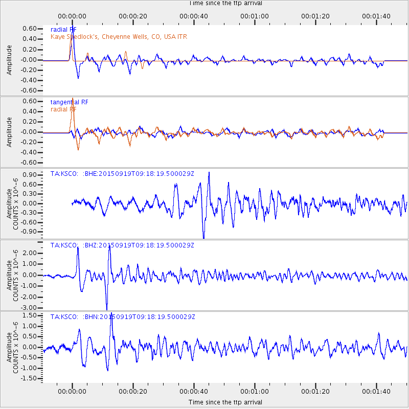
KSCO Kaye Shedlock's, Cheyenne Wells, CO, USA - Earthquake Result Viewer

| Earthquake location: |
Near Coast Of Central Chile |
| Earthquake latitude/longitude: |
-31.1/-71.6 |
| Earthquake time(UTC): |
2015/09/19 (262) 09:07:08 GMT |
| Earthquake Depth: |
23 km |
| Earthquake Magnitude: |
6.1 MWP |
| Earthquake Catalog/Contributor: |
NEIC PDE/NEIC COMCAT |
|
| Network: |
TA USArray Transportable Network (new EarthScope stations) |
| Station: |
KSCO Kaye Shedlock's, Cheyenne Wells, CO, USA |
| Lat/Lon: |
39.01 N/102.63 W |
| Elevation: |
1382 m |
|
| Distance: |
75.5 deg |
| Az: |
335.503 deg |
| Baz: |
152.839 deg |
| Ray Param: |
0.051600136 |
| Estimated Moho Depth: |
35.25 km |
| Estimated Crust Vp/Vs: |
1.92 |
| Assumed Crust Vp: |
6.242 km/s |
| Estimated Crust Vs: |
3.247 km/s |
| Estimated Crust Poisson's Ratio: |
0.31 |
|
| Radial Match: |
92.21416 % |
| Radial Bump: |
363 |
| Transverse Match: |
69.88054 % |
| Transverse Bump: |
400 |
| SOD ConfigId: |
7422571 |
| Insert Time: |
2019-04-20 22:41:12.303 +0000 |
| GWidth: |
2.5 |
| Max Bumps: |
400 |
| Tol: |
0.001 |
|
Signal To Noise
| Channel | StoN | STA | LTA |
| TA:KSCO: :BHZ:20150919T09:18:19.500029Z | 10.456266 | 9.693671E-7 | 9.270681E-8 |
| TA:KSCO: :BHN:20150919T09:18:19.500029Z | 4.004475 | 5.2236203E-7 | 1.3044456E-7 |
| TA:KSCO: :BHE:20150919T09:18:19.500029Z | 2.3765316 | 3.0858408E-7 | 1.298464E-7 |
| Arrivals |
| Ps | 5.4 SECOND |
| PpPs | 16 SECOND |
| PsPs/PpSs | 21 SECOND |


