You are here: Home > Network List > TA - USArray Transportable Network (new EarthScope stations) Stations List
> Station N59A State Game Land 141, Hazleton, PA, USA > Earthquake Result Viewer
N59A State Game Land 141, Hazleton, PA, USA - Earthquake Result Viewer
| Earthquake location: |
Near Coast Of Central Chile |
| Earthquake latitude/longitude: |
-31.1/-71.6 |
| Earthquake time(UTC): |
2015/09/19 (262) 09:07:08 GMT |
| Earthquake Depth: |
23 km |
| Earthquake Magnitude: |
6.1 MWP |
| Earthquake Catalog/Contributor: |
NEIC PDE/NEIC COMCAT |
|
| Network: |
TA USArray Transportable Network (new EarthScope stations) |
| Station: |
N59A State Game Land 141, Hazleton, PA, USA |
| Lat/Lon: |
40.92 N/75.77 W |
| Elevation: |
508 m |
|
| Distance: |
71.8 deg |
| Az: |
356.683 deg |
| Baz: |
176.245 deg |
| Ray Param: |
0.054079067 |
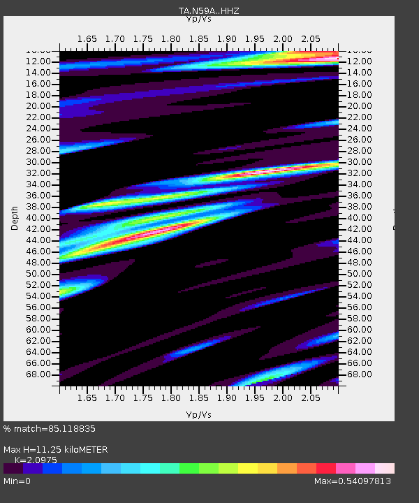
| Estimated Moho Depth: |
11.25 km |
| Estimated Crust Vp/Vs: |
2.10 |
| Assumed Crust Vp: |
6.283 km/s |
| Estimated Crust Vs: |
2.996 km/s |
| Estimated Crust Poisson's Ratio: |
0.35 |
|
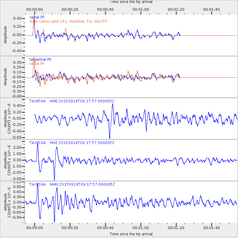
| Radial Match: |
85.118835 % |
| Radial Bump: |
400 |
| Transverse Match: |
62.578846 % |
| Transverse Bump: |
400 |
| SOD ConfigId: |
7422571 |
| Insert Time: |
2019-04-20 22:41:24.898 +0000 |
| GWidth: |
2.5 |
| Max Bumps: |
400 |
| Tol: |
0.001 |
|
Signal To Noise
| Channel | StoN | STA | LTA |
| TA:N59A: :HHZ:20150919T09:17:57.600005Z | 7.9706397 | 1.1461851E-6 | 1.4380089E-7 |
| TA:N59A: :HHN:20150919T09:17:57.600005Z | 5.0358567 | 4.6642776E-7 | 9.2621335E-8 |
| TA:N59A: :HHE:20150919T09:17:57.600005Z | 1.8078392 | 1.4642546E-7 | 8.0994745E-8 |
| Arrivals |
| Ps | 2.0 SECOND |
| PpPs | 5.4 SECOND |
| PsPs/PpSs | 7.4 SECOND |


