You are here: Home > Network List > TA - USArray Transportable Network (new EarthScope stations) Stations List
> Station O48A Farmland, IN, USA > Earthquake Result Viewer
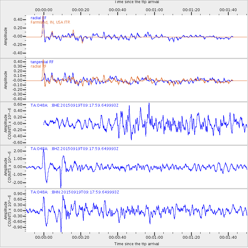
O48A Farmland, IN, USA - Earthquake Result Viewer
*The percent match for this event was below the threshold and hence no stack was calculated.
| Earthquake location: |
Near Coast Of Central Chile |
| Earthquake latitude/longitude: |
-31.1/-71.6 |
| Earthquake time(UTC): |
2015/09/19 (262) 09:07:08 GMT |
| Earthquake Depth: |
23 km |
| Earthquake Magnitude: |
6.1 MWP |
| Earthquake Catalog/Contributor: |
NEIC PDE/NEIC COMCAT |
|
| Network: |
TA USArray Transportable Network (new EarthScope stations) |
| Station: |
O48A Farmland, IN, USA |
| Lat/Lon: |
40.26 N/85.16 W |
| Elevation: |
300 m |
|
| Distance: |
72.1 deg |
| Az: |
349.145 deg |
| Baz: |
167.815 deg |
| Ray Param: |
$rayparam |
*The percent match for this event was below the threshold and hence was not used in the summary stack. |
|
| Radial Match: |
72.42659 % |
| Radial Bump: |
400 |
| Transverse Match: |
69.932976 % |
| Transverse Bump: |
400 |
| SOD ConfigId: |
7422571 |
| Insert Time: |
2019-04-20 22:41:28.236 +0000 |
| GWidth: |
2.5 |
| Max Bumps: |
400 |
| Tol: |
0.001 |
|
Signal To Noise
| Channel | StoN | STA | LTA |
| TA:O48A: :BHZ:20150919T09:17:59.649993Z | 10.256916 | 1.1113955E-6 | 1.08355714E-7 |
| TA:O48A: :BHN:20150919T09:17:59.649993Z | 3.8965886 | 4.2520645E-7 | 1.09122745E-7 |
| TA:O48A: :BHE:20150919T09:17:59.649993Z | 1.7550664 | 1.5187143E-7 | 8.653316E-8 |
| Arrivals |
| Ps | |
| PpPs | |
| PsPs/PpSs | |


