You are here: Home > Network List > TA - USArray Transportable Network (new EarthScope stations) Stations List
> Station T25A Trinidad, CO, USA > Earthquake Result Viewer
T25A Trinidad, CO, USA - Earthquake Result Viewer
| Earthquake location: |
Near Coast Of Central Chile |
| Earthquake latitude/longitude: |
-31.1/-71.6 |
| Earthquake time(UTC): |
2015/09/19 (262) 09:07:08 GMT |
| Earthquake Depth: |
23 km |
| Earthquake Magnitude: |
6.1 MWP |
| Earthquake Catalog/Contributor: |
NEIC PDE/NEIC COMCAT |
|
| Network: |
TA USArray Transportable Network (new EarthScope stations) |
| Station: |
T25A Trinidad, CO, USA |
| Lat/Lon: |
37.14 N/104.41 W |
| Elevation: |
2017 m |
|
| Distance: |
74.5 deg |
| Az: |
333.308 deg |
| Baz: |
151.176 deg |
| Ray Param: |
0.05225772 |
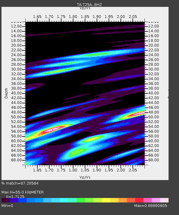
| Estimated Moho Depth: |
55.0 km |
| Estimated Crust Vp/Vs: |
1.71 |
| Assumed Crust Vp: |
6.316 km/s |
| Estimated Crust Vs: |
3.688 km/s |
| Estimated Crust Poisson's Ratio: |
0.24 |
|
| Radial Match: |
87.28564 % |
| Radial Bump: |
379 |
| Transverse Match: |
80.97846 % |
| Transverse Bump: |
400 |
| SOD ConfigId: |
7422571 |
| Insert Time: |
2019-04-20 22:41:38.572 +0000 |
| GWidth: |
2.5 |
| Max Bumps: |
400 |
| Tol: |
0.001 |
|

Signal To Noise
| Channel | StoN | STA | LTA |
| TA:T25A: :BHZ:20150919T09:18:13.800017Z | 9.784782 | 8.320688E-7 | 8.503703E-8 |
| TA:T25A: :BHN:20150919T09:18:13.800017Z | 5.088403 | 3.4663628E-7 | 6.8122795E-8 |
| TA:T25A: :BHE:20150919T09:18:13.800017Z | 3.924485 | 2.234395E-7 | 5.693473E-8 |
| Arrivals |
| Ps | 6.4 SECOND |
| PpPs | 23 SECOND |
| PsPs/PpSs | 29 SECOND |


