You are here: Home > Network List > IU - Global Seismograph Network (GSN - IRIS/USGS) Stations List
> Station COL College Outpost, Alaska, USA > Earthquake Result Viewer
COL College Outpost, Alaska, USA - Earthquake Result Viewer

| Earthquake location: |
New Guinea, Papua New Guinea |
| Earthquake latitude/longitude: |
-4.4/142.6 |
| Earthquake time(UTC): |
1991/05/17 (137) 02:31:24 GMT |
| Earthquake Depth: |
47 km |
| Earthquake Magnitude: |
5.9 MB, 6.0 MS, 6.0 UNKNOWN |
| Earthquake Catalog/Contributor: |
WHDF/NEIC |
|
| Network: |
IU Global Seismograph Network (GSN - IRIS/USGS) |
| Station: |
COL College Outpost, Alaska, USA |
| Lat/Lon: |
64.90 N/147.79 W |
| Elevation: |
320 m |
|
| Distance: |
85.4 deg |
| Az: |
23.643 deg |
| Baz: |
249.634 deg |
| Ray Param: |
0.04469714 |
| Estimated Moho Depth: |
33.25 km |
| Estimated Crust Vp/Vs: |
1.60 |
| Assumed Crust Vp: |
6.566 km/s |
| Estimated Crust Vs: |
4.097 km/s |
| Estimated Crust Poisson's Ratio: |
0.18 |
|
| Radial Match: |
86.91628 % |
| Radial Bump: |
400 |
| Transverse Match: |
77.92699 % |
| Transverse Bump: |
400 |
| SOD ConfigId: |
16938 |
| Insert Time: |
2010-03-04 20:13:33.907 +0000 |
| GWidth: |
2.5 |
| Max Bumps: |
400 |
| Tol: |
0.001 |
|
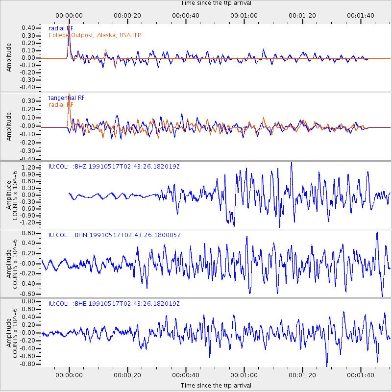
Signal To Noise
| Channel | StoN | STA | LTA |
| IU:COL: :BHN:19910517T02:43:26.180005Z | 0.9050329 | 6.402564E-8 | 7.0743994E-8 |
| IU:COL: :BHE:19910517T02:43:26.182019Z | 1.3706716 | 4.9725475E-8 | 3.6278184E-8 |
| IU:COL: :BHZ:19910517T02:43:26.182019Z | 2.1595044 | 1.5461411E-7 | 7.159703E-8 |
| Arrivals |
| Ps | 3.1 SECOND |
| PpPs | 13 SECOND |
| PsPs/PpSs | 16 SECOND |


