You are here: Home > Network List > IU - Global Seismograph Network (GSN - IRIS/USGS) Stations List
> Station COL College Outpost, Alaska, USA > Earthquake Result Viewer
COL College Outpost, Alaska, USA - Earthquake Result Viewer
| Earthquake location: |
Minahassa Peninsula, Sulawesi |
| Earthquake latitude/longitude: |
1.2/122.8 |
| Earthquake time(UTC): |
1991/06/20 (171) 05:18:52 GMT |
| Earthquake Depth: |
33 km |
| Earthquake Magnitude: |
6.2 MB, 7.1 MS, 7.2 UNKNOWN |
| Earthquake Catalog/Contributor: |
WHDF/NEIC |
|
| Network: |
IU Global Seismograph Network (GSN - IRIS/USGS) |
| Station: |
COL College Outpost, Alaska, USA |
| Lat/Lon: |
64.90 N/147.79 W |
| Elevation: |
320 m |
|
| Distance: |
88.7 deg |
| Az: |
25.254 deg |
| Baz: |
269.993 deg |
| Ray Param: |
0.042339258 |
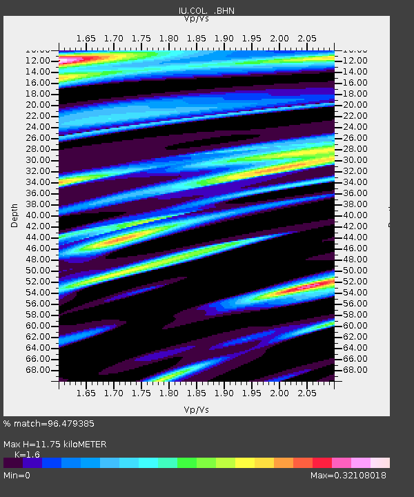
| Estimated Moho Depth: |
11.75 km |
| Estimated Crust Vp/Vs: |
1.60 |
| Assumed Crust Vp: |
6.566 km/s |
| Estimated Crust Vs: |
4.104 km/s |
| Estimated Crust Poisson's Ratio: |
0.18 |
|
| Radial Match: |
96.479385 % |
| Radial Bump: |
400 |
| Transverse Match: |
76.74045 % |
| Transverse Bump: |
400 |
| SOD ConfigId: |
16938 |
| Insert Time: |
2010-03-04 20:13:43.961 +0000 |
| GWidth: |
2.5 |
| Max Bumps: |
400 |
| Tol: |
0.001 |
|

Signal To Noise
| Channel | StoN | STA | LTA |
| IU:COL: :BHN:19910620T05:31:11.380005Z | 1.8008105 | 6.991819E-8 | 3.8825956E-8 |
| IU:COL: :BHE:19910620T05:31:11.380005Z | 4.9499493 | 3.8601974E-7 | 7.798458E-8 |
| IU:COL: :BHZ:19910620T05:31:11.380005Z | 17.739544 | 1.171757E-6 | 6.605339E-8 |
| Arrivals |
| Ps | 1.1 SECOND |
| PpPs | 4.5 SECOND |
| PsPs/PpSs | 5.6 SECOND |


