You are here: Home > Network List > UW - Pacific Northwest Regional Seismic Network Stations List
> Station LEBA Lebam, WA, USA > Earthquake Result Viewer
LEBA Lebam, WA, USA - Earthquake Result Viewer
*The percent match for this event was below the threshold and hence no stack was calculated.
| Earthquake location: |
Near Coast Of Central Chile |
| Earthquake latitude/longitude: |
-31.1/-71.6 |
| Earthquake time(UTC): |
2015/09/19 (262) 09:07:08 GMT |
| Earthquake Depth: |
23 km |
| Earthquake Magnitude: |
6.1 MWP |
| Earthquake Catalog/Contributor: |
NEIC PDE/NEIC COMCAT |
|
| Network: |
UW Pacific Northwest Regional Seismic Network |
| Station: |
LEBA Lebam, WA, USA |
| Lat/Lon: |
46.55 N/123.56 W |
| Elevation: |
73 m |
|
| Distance: |
90.4 deg |
| Az: |
327.075 deg |
| Baz: |
137.511 deg |
| Ray Param: |
$rayparam |
*The percent match for this event was below the threshold and hence was not used in the summary stack. |
|
| Radial Match: |
61.884995 % |
| Radial Bump: |
400 |
| Transverse Match: |
68.67005 % |
| Transverse Bump: |
400 |
| SOD ConfigId: |
7422571 |
| Insert Time: |
2019-04-20 22:42:39.898 +0000 |
| GWidth: |
2.5 |
| Max Bumps: |
400 |
| Tol: |
0.001 |
|
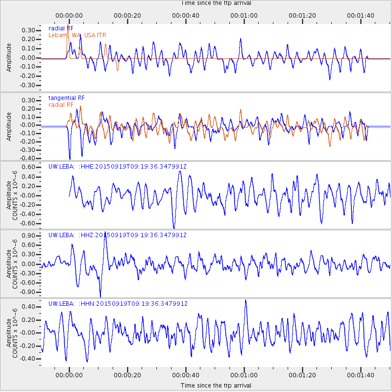
Signal To Noise
| Channel | StoN | STA | LTA |
| UW:LEBA: :HHZ:20150919T09:19:36.347991Z | 3.6289258 | 3.7653672E-7 | 1.0375983E-7 |
| UW:LEBA: :HHN:20150919T09:19:36.347991Z | 1.3721354 | 1.7780513E-7 | 1.2958279E-7 |
| UW:LEBA: :HHE:20150919T09:19:36.347991Z | 0.66682935 | 1.1305014E-7 | 1.6953385E-7 |
| Arrivals |
| Ps | |
| PpPs | |
| PsPs/PpSs | |


