You are here: Home > Network List > IU - Global Seismograph Network (GSN - IRIS/USGS) Stations List
> Station COL College Outpost, Alaska, USA > Earthquake Result Viewer
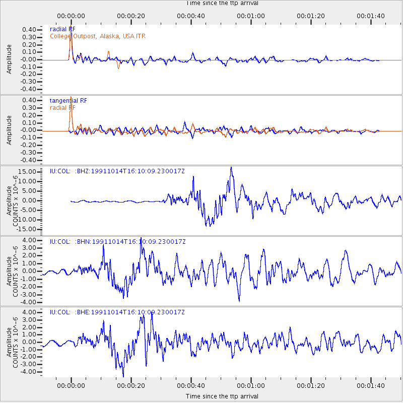
COL College Outpost, Alaska, USA - Earthquake Result Viewer

| Earthquake location: |
Solomon Islands |
| Earthquake latitude/longitude: |
-9.1/158.5 |
| Earthquake time(UTC): |
1991/10/14 (287) 15:58:14 GMT |
| Earthquake Depth: |
33 km |
| Earthquake Magnitude: |
6.2 MB, 7.1 MS |
| Earthquake Catalog/Contributor: |
WHDF/NEIC |
|
| Network: |
IU Global Seismograph Network (GSN - IRIS/USGS) |
| Station: |
COL College Outpost, Alaska, USA |
| Lat/Lon: |
64.90 N/147.79 W |
| Elevation: |
320 m |
|
| Distance: |
83.8 deg |
| Az: |
20.234 deg |
| Baz: |
233.214 deg |
| Ray Param: |
0.045884613 |
| Estimated Moho Depth: |
51.75 km |
| Estimated Crust Vp/Vs: |
1.60 |
| Assumed Crust Vp: |
6.566 km/s |
| Estimated Crust Vs: |
4.104 km/s |
| Estimated Crust Poisson's Ratio: |
0.18 |
|
| Radial Match: |
95.16762 % |
| Radial Bump: |
398 |
| Transverse Match: |
68.941185 % |
| Transverse Bump: |
400 |
| SOD ConfigId: |
16938 |
| Insert Time: |
2010-03-04 20:13:59.395 +0000 |
| GWidth: |
2.5 |
| Max Bumps: |
400 |
| Tol: |
0.001 |
|
Signal To Noise
| Channel | StoN | STA | LTA |
| IU:COL: :BHN:19911014T16:10:09.230017Z | 1.1222107 | 3.4343367E-7 | 3.0603314E-7 |
| IU:COL: :BHE:19911014T16:10:09.230017Z | 1.8930515 | 5.27906E-7 | 2.7886512E-7 |
| IU:COL: :BHZ:19911014T16:10:09.230017Z | 5.7987304 | 1.6306668E-6 | 2.81211E-7 |
| Arrivals |
| Ps | 4.9 SECOND |
| PpPs | 20 SECOND |
| PsPs/PpSs | 25 SECOND |


