You are here: Home > Network List > IU - Global Seismograph Network (GSN - IRIS/USGS) Stations List
> Station COL College Outpost, Alaska, USA > Earthquake Result Viewer
COL College Outpost, Alaska, USA - Earthquake Result Viewer

| Earthquake location: |
Eastern New Guinea Reg., P.N.G. |
| Earthquake latitude/longitude: |
-6.1/147.6 |
| Earthquake time(UTC): |
1992/05/15 (136) 07:05:04 GMT |
| Earthquake Depth: |
50 km |
| Earthquake Magnitude: |
6.2 MB, 7.1 MS |
| Earthquake Catalog/Contributor: |
WHDF/NEIC |
|
| Network: |
IU Global Seismograph Network (GSN - IRIS/USGS) |
| Station: |
COL College Outpost, Alaska, USA |
| Lat/Lon: |
64.90 N/147.79 W |
| Elevation: |
320 m |
|
| Distance: |
85.0 deg |
| Az: |
22.757 deg |
| Baz: |
244.409 deg |
| Ray Param: |
0.044983204 |
| Estimated Moho Depth: |
33.5 km |
| Estimated Crust Vp/Vs: |
1.60 |
| Assumed Crust Vp: |
6.566 km/s |
| Estimated Crust Vs: |
4.104 km/s |
| Estimated Crust Poisson's Ratio: |
0.18 |
|
| Radial Match: |
97.97132 % |
| Radial Bump: |
333 |
| Transverse Match: |
83.74478 % |
| Transverse Bump: |
400 |
| SOD ConfigId: |
16938 |
| Insert Time: |
2010-03-04 20:14:50.682 +0000 |
| GWidth: |
2.5 |
| Max Bumps: |
400 |
| Tol: |
0.001 |
|
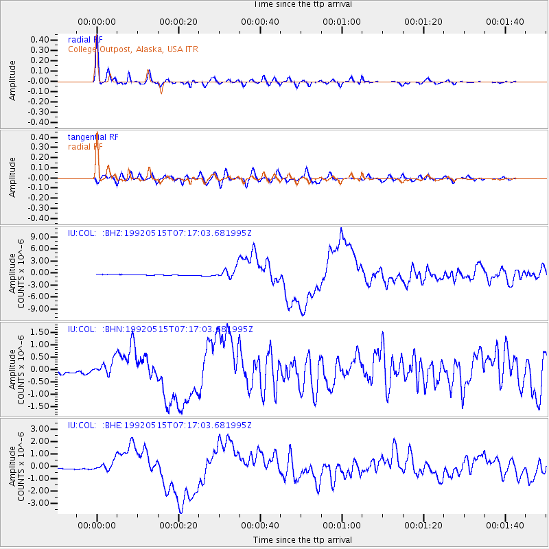
Signal To Noise
| Channel | StoN | STA | LTA |
| IU:COL: :BHN:19920515T07:17:03.681995Z | 5.2446356 | 3.2575548E-7 | 6.211213E-8 |
| IU:COL: :BHE:19920515T07:17:03.681995Z | 4.2980103 | 3.9590708E-7 | 9.2114036E-8 |
| IU:COL: :BHZ:19920515T07:17:03.681995Z | 12.407927 | 1.4774726E-6 | 1.190749E-7 |
| Arrivals |
| Ps | 3.1 SECOND |
| PpPs | 13 SECOND |
| PsPs/PpSs | 16 SECOND |


