You are here: Home > Network List > N4 - Central and EAstern US Network Stations List
> Station M63A Gales Ferry, CT, USA > Earthquake Result Viewer
M63A Gales Ferry, CT, USA - Earthquake Result Viewer
| Earthquake location: |
Off Coast Of Central Chile |
| Earthquake latitude/longitude: |
-32.3/-72.1 |
| Earthquake time(UTC): |
2015/09/19 (262) 12:52:19 GMT |
| Earthquake Depth: |
11 km |
| Earthquake Magnitude: |
6.2 MWB |
| Earthquake Catalog/Contributor: |
NEIC PDE/NEIC COMCAT |
|
| Network: |
N4 Central and EAstern US Network |
| Station: |
M63A Gales Ferry, CT, USA |
| Lat/Lon: |
41.40 N/72.05 W |
| Elevation: |
44 m |
|
| Distance: |
73.4 deg |
| Az: |
0.035 deg |
| Baz: |
180.04 deg |
| Ray Param: |
0.053045616 |
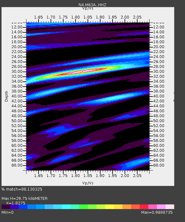
| Estimated Moho Depth: |
29.75 km |
| Estimated Crust Vp/Vs: |
1.83 |
| Assumed Crust Vp: |
6.472 km/s |
| Estimated Crust Vs: |
3.541 km/s |
| Estimated Crust Poisson's Ratio: |
0.29 |
|
| Radial Match: |
88.130325 % |
| Radial Bump: |
297 |
| Transverse Match: |
58.55938 % |
| Transverse Bump: |
400 |
| SOD ConfigId: |
7422571 |
| Insert Time: |
2019-04-20 22:50:00.730 +0000 |
| GWidth: |
2.5 |
| Max Bumps: |
400 |
| Tol: |
0.001 |
|

Signal To Noise
| Channel | StoN | STA | LTA |
| N4:M63A: :HHZ:20150919T13:03:19.429973Z | 7.2304606 | 8.673798E-7 | 1.199619E-7 |
| N4:M63A: :HHN:20150919T13:03:19.429973Z | 4.1712246 | 3.4871485E-7 | 8.360012E-8 |
| N4:M63A: :HHE:20150919T13:03:19.429973Z | 0.82498306 | 7.985501E-8 | 9.679594E-8 |
| Arrivals |
| Ps | 3.9 SECOND |
| PpPs | 13 SECOND |
| PsPs/PpSs | 17 SECOND |


