You are here: Home > Network List > N4 - Central and EAstern US Network Stations List
> Station N35B Tabor, IA, USA > Earthquake Result Viewer
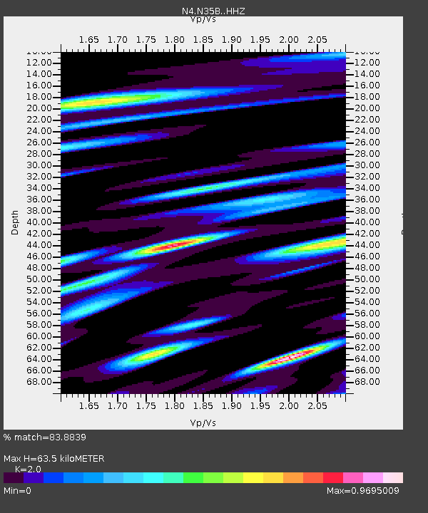
N35B Tabor, IA, USA - Earthquake Result Viewer
| Earthquake location: |
Off Coast Of Central Chile |
| Earthquake latitude/longitude: |
-32.3/-72.1 |
| Earthquake time(UTC): |
2015/09/19 (262) 12:52:19 GMT |
| Earthquake Depth: |
11 km |
| Earthquake Magnitude: |
6.2 MWB |
| Earthquake Catalog/Contributor: |
NEIC PDE/NEIC COMCAT |
|
| Network: |
N4 Central and EAstern US Network |
| Station: |
N35B Tabor, IA, USA |
| Lat/Lon: |
40.86 N/95.64 W |
| Elevation: |
353 m |
|
| Distance: |
76.0 deg |
| Az: |
341.801 deg |
| Baz: |
159.599 deg |
| Ray Param: |
0.051279243 |
| Estimated Moho Depth: |
63.5 km |
| Estimated Crust Vp/Vs: |
2.00 |
| Assumed Crust Vp: |
6.498 km/s |
| Estimated Crust Vs: |
3.249 km/s |
| Estimated Crust Poisson's Ratio: |
0.33 |
|
| Radial Match: |
83.8839 % |
| Radial Bump: |
400 |
| Transverse Match: |
66.37581 % |
| Transverse Bump: |
400 |
| SOD ConfigId: |
7422571 |
| Insert Time: |
2019-04-20 22:50:03.759 +0000 |
| GWidth: |
2.5 |
| Max Bumps: |
400 |
| Tol: |
0.001 |
|

Signal To Noise
| Channel | StoN | STA | LTA |
| N4:N35B: :HHZ:20150919T13:03:34.720012Z | 3.6184127 | 6.4083264E-7 | 1.7710323E-7 |
| N4:N35B: :HHN:20150919T13:03:34.720012Z | 1.5017079 | 4.135588E-7 | 2.7539232E-7 |
| N4:N35B: :HHE:20150919T13:03:34.720012Z | 1.0054456 | 2.600048E-7 | 2.585966E-7 |
| Arrivals |
| Ps | 10 SECOND |
| PpPs | 28 SECOND |
| PsPs/PpSs | 39 SECOND |


