You are here: Home > Network List > IU - Global Seismograph Network (GSN - IRIS/USGS) Stations List
> Station COL College Outpost, Alaska, USA > Earthquake Result Viewer
COL College Outpost, Alaska, USA - Earthquake Result Viewer
| Earthquake location: |
Banda Sea |
| Earthquake latitude/longitude: |
-6.5/130.4 |
| Earthquake time(UTC): |
1992/12/20 (355) 20:52:42 GMT |
| Earthquake Depth: |
33 km |
| Earthquake Magnitude: |
6.6 MB, 7.1 MS, 7.0 UNKNOWN |
| Earthquake Catalog/Contributor: |
WHDF/NEIC |
|
| Network: |
IU Global Seismograph Network (GSN - IRIS/USGS) |
| Station: |
COL College Outpost, Alaska, USA |
| Lat/Lon: |
64.90 N/147.79 W |
| Elevation: |
320 m |
|
| Distance: |
92.4 deg |
| Az: |
24.996 deg |
| Baz: |
259.856 deg |
| Ray Param: |
0.041458644 |
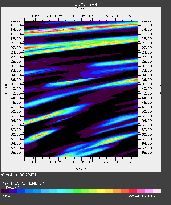
| Estimated Moho Depth: |
13.75 km |
| Estimated Crust Vp/Vs: |
1.77 |
| Assumed Crust Vp: |
6.566 km/s |
| Estimated Crust Vs: |
3.71 km/s |
| Estimated Crust Poisson's Ratio: |
0.27 |
|
| Radial Match: |
88.79671 % |
| Radial Bump: |
400 |
| Transverse Match: |
86.729 % |
| Transverse Bump: |
400 |
| SOD ConfigId: |
16938 |
| Insert Time: |
2010-03-04 20:15:49.005 +0000 |
| GWidth: |
2.5 |
| Max Bumps: |
400 |
| Tol: |
0.001 |
|

Signal To Noise
| Channel | StoN | STA | LTA |
| IU:COL: :BHN:19921220T21:05:18.372009Z | 1.0497168 | 1.9464937E-7 | 1.8543038E-7 |
| IU:COL: :BHE:19921220T21:05:18.374023Z | 3.14161 | 4.409767E-7 | 1.4036647E-7 |
| IU:COL: :BHZ:19921220T21:05:18.372009Z | 11.782974 | 1.5710107E-6 | 1.3332888E-7 |
| Arrivals |
| Ps | 1.6 SECOND |
| PpPs | 5.7 SECOND |
| PsPs/PpSs | 7.3 SECOND |


