You are here: Home > Network List > TA - USArray Transportable Network (new EarthScope stations) Stations List
> Station 833A Chaparral WMA, Artesia Wells, TX, USA > Earthquake Result Viewer
833A Chaparral WMA, Artesia Wells, TX, USA - Earthquake Result Viewer
| Earthquake location: |
Off Coast Of Central Chile |
| Earthquake latitude/longitude: |
-32.3/-72.1 |
| Earthquake time(UTC): |
2015/09/19 (262) 12:52:19 GMT |
| Earthquake Depth: |
11 km |
| Earthquake Magnitude: |
6.2 MWB |
| Earthquake Catalog/Contributor: |
NEIC PDE/NEIC COMCAT |
|
| Network: |
TA USArray Transportable Network (new EarthScope stations) |
| Station: |
833A Chaparral WMA, Artesia Wells, TX, USA |
| Lat/Lon: |
28.32 N/99.39 W |
| Elevation: |
171 m |
|
| Distance: |
65.7 deg |
| Az: |
333.654 deg |
| Baz: |
154.777 deg |
| Ray Param: |
0.058116667 |
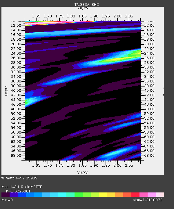
| Estimated Moho Depth: |
11.0 km |
| Estimated Crust Vp/Vs: |
1.62 |
| Assumed Crust Vp: |
6.347 km/s |
| Estimated Crust Vs: |
3.912 km/s |
| Estimated Crust Poisson's Ratio: |
0.19 |
|
| Radial Match: |
92.85939 % |
| Radial Bump: |
362 |
| Transverse Match: |
88.771996 % |
| Transverse Bump: |
382 |
| SOD ConfigId: |
7422571 |
| Insert Time: |
2019-04-20 22:52:59.709 +0000 |
| GWidth: |
2.5 |
| Max Bumps: |
400 |
| Tol: |
0.001 |
|

Signal To Noise
| Channel | StoN | STA | LTA |
| TA:833A: :BHZ:20150919T13:02:32.050029Z | 6.3834853 | 5.935691E-7 | 9.298511E-8 |
| TA:833A: :BHN:20150919T13:02:32.050029Z | 2.2600696 | 2.1187998E-7 | 9.3749314E-8 |
| TA:833A: :BHE:20150919T13:02:32.050029Z | 1.6875247 | 1.649566E-7 | 9.775063E-8 |
| Arrivals |
| Ps | 1.1 SECOND |
| PpPs | 4.3 SECOND |
| PsPs/PpSs | 5.5 SECOND |


