You are here: Home > Network List > IU - Global Seismograph Network (GSN - IRIS/USGS) Stations List
> Station COL College Outpost, Alaska, USA > Earthquake Result Viewer
COL College Outpost, Alaska, USA - Earthquake Result Viewer

| Earthquake location: |
Near East Coast Of Kamchatka |
| Earthquake latitude/longitude: |
51.2/157.7 |
| Earthquake time(UTC): |
1993/06/12 (163) 20:33:26 GMT |
| Earthquake Depth: |
49 km |
| Earthquake Magnitude: |
6.0 MB, 5.9 MS, 5.5 UNKNOWN, 6.3 MW |
| Earthquake Catalog/Contributor: |
WHDF/NEIC |
|
| Network: |
IU Global Seismograph Network (GSN - IRIS/USGS) |
| Station: |
COL College Outpost, Alaska, USA |
| Lat/Lon: |
64.90 N/147.79 W |
| Elevation: |
320 m |
|
| Distance: |
30.8 deg |
| Az: |
42.716 deg |
| Baz: |
270.122 deg |
| Ray Param: |
0.07918241 |
| Estimated Moho Depth: |
34.25 km |
| Estimated Crust Vp/Vs: |
1.60 |
| Assumed Crust Vp: |
6.566 km/s |
| Estimated Crust Vs: |
4.104 km/s |
| Estimated Crust Poisson's Ratio: |
0.18 |
|
| Radial Match: |
93.501305 % |
| Radial Bump: |
327 |
| Transverse Match: |
79.951 % |
| Transverse Bump: |
400 |
| SOD ConfigId: |
16938 |
| Insert Time: |
2010-03-04 20:16:38.405 +0000 |
| GWidth: |
2.5 |
| Max Bumps: |
400 |
| Tol: |
0.001 |
|
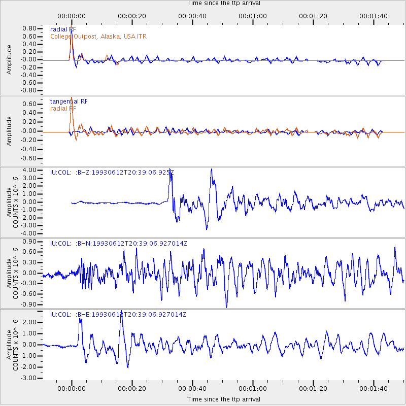
Signal To Noise
| Channel | StoN | STA | LTA |
| IU:COL: :BHN:19930612T20:39:06.927014Z | 2.5673673 | 1.7074417E-7 | 6.650555E-8 |
| IU:COL: :BHE:19930612T20:39:06.927014Z | 14.426743 | 1.053167E-6 | 7.300102E-8 |
| IU:COL: :BHZ:19930612T20:39:06.925Z | 26.39489 | 1.6921277E-6 | 6.410816E-8 |
| Arrivals |
| Ps | 3.4 SECOND |
| PpPs | 12 SECOND |
| PsPs/PpSs | 16 SECOND |


